Papers by Chanseng Phongpachith

Chanseng Phongpachith, 2014
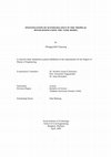
Lao PDR is expected to be seriously affected by the impacts of climate change. The rural poor wit... more Lao PDR is expected to be seriously affected by the impacts of climate change. The rural poor with low incomes and a high dependency on traditional agricultural . Systems or on marginal lands are very likely to be particularly vulnerable especially flooding and drought. These impacts are being induced by observable changes in the climate including higher than usual intensity rainfall events during the raining season and extended dry seasons. The related risks include sudden flash-floods, landslides
and large-scale land-erosion on slopes and - recently - typhoons in the south. These events can be very destructive not only altering the landscape, fauna and vegetation, but also destroying public infrastructure, property, productive land, agricultural assets and harvests. The poorest people was effected, who often live in the most fragile environment and are especially reliant on climate-sensitive agriculture sector, are highly vulnerable to climate change.
UNDP and the Ministry of Agriculture and Forestry (MAF) have established at the NAFRI for the formulation of the project “Improving the Resilience of the Agriculture Sector(IRAS) in Lao PDR to Climate Change Impacts
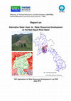
agriculture” as part of the NAPA follow-up activities. For fighting against impact form climate change in Lao PDR such as flood and drought in target areas are consideration. Flood impact agriculture area due to population rapid grow, land use change,increasing buildings are increasingly in zones at risk of flooding. These risk zones are expected to expand in the future predict Base line scenario in 2010, Climate change scenario 2040 and2070. This results in a significant threat to residents and economic assets. Study area was sellected of is still an important part of Champhone and Outhoumphone districts, Savannakhet province.

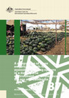
The Australian Centre for International Agricultural Research (ACIAR) was established in June 198... more The Australian Centre for International Agricultural Research (ACIAR) was established in June 1982 by an Act of the Australian Parliament. ACIAR operates as part of Australia's international development cooperation program, with a mission to achieve more productive and sustainable agricultural systems, for the benefit of developing countries and Australia. It commissions collaborative research between Australian and developing-country researchers in areas where Australia has special research competence. It also administers Australia's contribution to the International Agricultural Research Centres. Where trade names are used this constitutes neither endorsement of nor discrimination against any product by ACIAR. ACIAR TECHNICAL REPORTS SERIES This series of publications contains technical information resulting from ACIAR-supported programs, projects and workshops (for which proceedings are not published), reports on Centre-supported fact-finding studies, or reports on other topics resulting from ACIAR activities. Publications in the series are distributed internationally to selected individuals and scientific institutions, and are also available from ACIAR's website at <aciar.gov.au>.
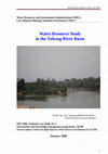
In Lao PDR, one of the less developed countries, water represents a valuable natural resource via... more In Lao PDR, one of the less developed countries, water represents a valuable natural resource via the development of hydropower dams and irrigation schemes. In the lower part of the Nam Ngum River Basin, the Vientiane plain is one of the largest food production areas of the country and the largest irrigated area in Lao PDR. While food demand is expected to continue to increase in the future, hydropower dams are under rapid development in the upper part of the basin, modifying the seasonal distribution of the river flow regimes. This study aims at assessing the current water supply and agricultural water demand in the Vientiane Plain and concluding whether the water resource is or may become a limiting factor for food production. The agricultural water demand is assessed from two types of data (characteristics of large-scale pumping stations and official statistics on irrigated areas) and using remote sensing analyses. Flow measurements of the Nam Ngum River were used to quantify the water supply. A 43-year time series of daily river discharge was reconstructed from actual discontinuous data recorded in the river reach where most of the pumping stations are found. Distinctions in the water resource assessment were made between pristine conditions (before the construction of the hydropower dams) and current conditions of water infrastructure development. A comparison of the water supply and demand indicates that during the 4 driest months of the year (January to April) when the river reaches its minimum level and the irrigation water demand is the highest, pumped volumes represent less than 30% of the river discharge. This ratio should decrease as new hydropower dams are built, storing and releasing more water during the wet and the dry season, respectively. These figures indicate that the availability of water in the Nam Ngum River is not a limiting factor for irrigation, even during the dry seasons of exceptionally dry years. The water demand could exceptionally exceed the water supply in the case of an extreme scenario of irrigation development with irrigated areas 3-fold larger than the current ones. Next analyses will consist in assessing how this water balance will be altered by the development of new hydropower dams and irrigation projects. Possible uses of water surplus will be prioritized, depending on their economic viability and benefits.
Country Report to Initiatives on Climate Change Adaptation Roadmap of Lao PDR
Volume 2, Chapter 8: Advancing Disaster Resilience and Climate Change Adaptation Roadmaps and Option for Implementation, 2019
A Chapter 8 of The Climate Change Adaptation (CCA) Roadmap in Lao PDR is based on Strategy on CC ... more A Chapter 8 of The Climate Change Adaptation (CCA) Roadmap in Lao PDR is based on Strategy on CC of Lao PDR (in March 2010 ), Climate Change Action Plan for 2013-2020( in April 2013) and Intended Nationally Determined Contributions, these approved by the Lao government. Both of the Strategy and Action plan on CC Management are expected to guide central and local government agencies as well as mass organizations, the private sector and other groups to play their parts in addressing CCA and Natural Disaster. These are also an importanting part of the Lao PDR contribution to international CC efforts under the UNFCC.
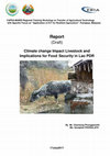
The tropical monsoonal climate, the histor ical agricultural activity in Laos and Cambodi... more The tropical monsoonal climate, the histor ical agricultural activity in Laos and Cambodia is predominately WS rice production in the rain-fed lowlands, which occupy 70–80% of the total rice cultivated area in those countries (Ly et al. 2013; Mitchell et al. 2014). As a ‘pathway out of poverty’(World Bank 2007), agricultural diversification is recognised as a way to improve the productivity and profitability of these lowland systems, and this has become a priority for both Lao and Cambodian gov ernments (Sarom 2007; Bunna et al. 2011; Mitchell et al. 2014). As well as improving WS rice varieties to withstand increasing incidence of drought and boost yield, there are opportunities to increase productivity and profitability of lowland rice production areas through the cultivation of dry season (DS) crops, including rice. This may be possible where water is available for irrigation or where, following the end of WS rains, residual soil moisture is sufficient to grow high-value, short duration crops. a number of physical, chemical and biological soil constraints that may restrict DS crop production, particularly in the lowlands. Additionally, soils can become moderately to strongly acidic under aerobic conditions, inhibiting plant growth through low cation exchange capacity (CEC), aluminium (Al) toxicity and/or high phosphorus (P) fixation during the DS (Haefele et al. 2014). Furthermore, traditional puddling methods and tillage operations for WS rice production result in a high bulk density soil layer, or ‘hardpan’, approximately 5 cm thick that lies beneath the soil surface at a depth of approximately 20 cm.
Empirical models that provide a more simplified mathematical model of crop physiological processes and that require fewer parameters provide a more useful analytical tool for farmers, water managers, policy makers and other end-users in less developed regions where data are limited (Dourado-Neto et al. 1998; Steduto et al. 2009a). For example, if the aim of a research project is to identify and subsequently alleviate water and soil constraints to increase non rice DS crop production in Laos and Cambodia, mod els based on these principles should be considered. The Food and Agriculture Organization of the United Nations (FAO) has developed two empirical models, CropWat and AquaCrop, which could potentially fulfil these needs based on primary design function, input requirements and availability and ease of use. A third empirical model, the soil water balance model (SWBM), developed locally by the National Agriculture and Forestry Research Institute of Laos (NAFRI), University of Queensland (UQ) and the International Rice Research Institute (IRRI).
Water International, 2014
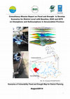
Hydropower and irrigation developments to address rising demand for food and energy are modifying... more Hydropower and irrigation developments to address rising demand for food and energy are modifying the water balance of the Mekong Basin. Infrastructure investment decisions are also frequently made from a sub-catchment perspective. This paper compares river flows to irrigation development stages in the Nam Ngum sub-basin where the potential for irrigation and hydropower expansion is largely untapped. We show that full hydropower development in this basin allows irrigation water use to triple, even as it reduces competition with environmental flow requirements. The implications for the wider Mekong are however unclear, particularly given uncertainty over parallel transformations elsewhere in the basin.
Volume 2, Chapter 8: Advancing Disaster Resilience and Climate Change Adaptation Roadmaps and Option for Implementation, 2019
A Chapter 8 of The Climate Change Adaptation (CCA) Roadmap in Lao PDR is based on Strategy on CC ... more A Chapter 8 of The Climate Change Adaptation (CCA) Roadmap in Lao PDR is based on Strategy on CC of Lao PDR (in March 2010 ), Climate Change
Action Plan for 2013-2020( in April 2013) and Intended Nationally Determined Contributions, these
approved by the Lao government. Both of the Strategy and Action plan on CC Management are
expected to guide central and local government agencies as well as mass organizations, the private
sector and other groups to play their parts in addressing CCA and Natural Disaster. These are also an
importanting part of the Lao PDR contribution to international CC efforts under the UNFCC.
Dr. Tayphasavanh Fengthong, Chanseng Phongpachith, Dr. Mayphou Mahachareunh,Dr. Bounpheng Philavong, Dr. Panom Phongmany, Dr. Visanou Hansana, Dr. Visith Khamleuisa, Dr. Naly Khaminsou, Mr. Vilakone Manyphousay, Ms. Somphone Phengkhammy, and others., 2019
Lao PDR is a landlocked country which has a tropical climate, with a rainy season from May to Nov... more Lao PDR is a landlocked country which has a tropical climate, with a rainy season from May to November and a dry season from December to April. Already vulnerable to extreme weather events, Lao PDR is predicted to experience rising temperatures, increased rainfall variability and more severe and frequent floods and drought . The increased incidence of extreme weather events could exacerbate food insecurity, increase the risk of disease, threaten drinking-water supply and damage healthcare infrastructure [World Bank Climate Risk and Adaptation Country Profile, 2011]. Approximately 70% of the population of Lao PDR relies on natural resources for their livelihoods. With nearly 30% of GDP coming from the agriculture sector, climate change poses a major threat to food security [Lao PDR INDC, 2015]. The National Strategy on Climate Change (NSCC) of Lao PDR was approved in early 2010 with the specific aim to 'secure a future where Lao PDR is capable of mitigating and adapting to changing climatic conditions in a way that promotes sustainable economic development, reduces poverty, protects public health and safety, enhances the quality of Lao PDR’s natural environment, and advances the quality of life for all Lao People' [Lao PDR INDC, 2015]. Lao PDR aims to increase forest coverage to 70% of total land area by 2020, reducing the risk of flooding and acting as a carbon sink, and aims to increase renewable energy to 30% of energy consumption by 2025 [Lao PDR INDC, 2015]. In Lao PDR, under a high emissions scenario, mean annual temperature is projected to rise by about 4.5°C on average The Lao People’s Democratic Republic [Lao PDR] is a lowermiddle income country with one of the fastest growing economies in the Asia Pacific region [World Bank Country Overview, 2016]. The landlocked country has a tropical climate, with a rainy season from May to November and a dry season from December to April. Already vulnerable to extreme weather events, Lao PDR is predicted to experience rising temperatures, increased rainfall variability and more severe and frequent floods and drought [LAO PDR INDC, 2015]. The increased incidence of extreme weather events could exacerbate food insecurity, increase the risk of disease, threaten drinking-water supply and damage healthcare infrastructure [World Bank Climate Risk and Adaptation Country Profile, 2011]. Approximately 70% of the population of Lao PDR relies on natural resources for their livelihoods. With nearly 30% of GDP coming from the agriculture sector, climate change poses a major threat to food security [Lao PDR INDC, 2015]. The National Strategy on Climate Change (NSCC) of Lao PDR was approved in early 2010 with the specific aim to 'secure a future where Lao PDR is capable of mitigating and adapting to changing climatic conditions in a way that promotes sustainable economic development, reduces poverty, protects public health and safety, enhances the quality of Lao PDR’s natural environment, and advances the quality of life for all Lao People' [Lao PDR INDC, 2015]. Lao PDR aims to increase forest coverage to 70% of total land area by 2020, reducing the risk of flooding and acting as a carbon sink, and aims to increase renewable energy to 30% of energy consumption by 2025 [Lao PDR INDC, 2015]. In Lao PDR, under a high emissions scenario, mean annual temperature is projected to rise by about 4.5°C on average from 1990 to 2100. If global emissions decrease rapidly, the temperature rise is limited to about 1.4°C so the population at risk of malaria is projected to decline towards 2070, however, it is estimated that a low emissions scenario will lead to a greated decline in population at risk . • In Lao PDR, the mean relative vectorial capacity for dengue fever transmision is projected to increase under a high • A rapid reduction in global emissions could limit heat-related deaths in the elderly to about 15 deaths per 100,000 in 2080.
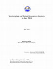
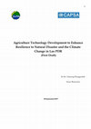
Lao PDR is a rich country of water resources and has its huge potential to develop water resource... more Lao PDR is a rich country of water resources and has its huge potential to develop water resources, especially hydro power and fresh water, it has remained largely untapped. Further, there is no comprehensive master plan on water resources development and management, systematically and synthetically. Planning and management of water resources sectors in Lao PDR is also fragmented, causing a lack of co ordination among agencies, due to no a key agency. There is no one specific ministry, such as ministry of water resources, to response directly to water resources development and management in Lao PDR.
water resources management are to
emphasize value of water resources, to provide sufficient amount of water during dry
season especially agricultural production and hydropower generation. A sustainable
development of water resources, it should be a implementing clearly Water policy
,Combination of water sectors, Human resources including research and awareness ,
implemented poor infrastructures condition of water sectors, construct National Water
Resources Management/Information System including synthetic data base, Survey water
resources in basin wide especially water shortage situations, and so on.
Lao PDR will be improved his economic conditions through development and management of water resources. In order to develop and manage water resources effectively and efficiently, what the strategies are drawn up is to be primary goal of this report.
Collaboration between Lao National Mekong Committee (LNMC)\PMO and Korea International Cooperation Agency (KOICA) Korea Water Resources Corporation (KOWACO)
Relationship was investigated between optimized coefficients of the tank model
and basin characte... more Relationship was investigated between optimized coefficients of the tank model
and basin characteristics . As result, many coefficients were correlated to basin area such
as topography and nearby location.
Rainfall and runoff data are often inadequate. This insufficiency of data prompted
a number of researchers to conduct studies on the development of hydrologic models.
Rainfall and runoff records are used to calibrate and verify the models. The tank model
procedure was applied to calibrate and verify the runoff. There is an estimation of model
parameter. It is considered the outlet coefficients of the tank model for tropical river
basins, which is constructed to describe the rainfall-runoff. First study area, Nam Ngum
river basin is selected at Ban NaLuang gauging station where is observed in north Lao
PDR (Laos). Second studies, Nam Songkhram river basin is selected Ban Tha Kok Deang
is observed a gauging station where is in northeast portion of the Khorat plateau. Last
study, Utaphao river basin is selected Code of NoX-90 where is in southern Thailand.
The calibration procedure of the tank model works efficiently and can be used in
general practice such as tropical regions even Lower Mekong Basin. In the pass had eight
basins were selected in the Lower Mekong and Chao Phraya river basins such as Sirikit
Dam, LamdomYai, Srinagarin, Nam Chi basin at Ban Chot, Hoai Rai basin at Ban Non
Kiang, Nam Mae Chan at Ban Yano Mai, and Nam Mun, in Thailand and Thac Buoi and
Chu Basins , in Vietnam. The total results are twelve thus we can estimate water balance
in the tropical river basins.
Lao PDR is a country undergoing rapid development. With a high percentage of the rural population... more Lao PDR is a country undergoing rapid development. With a high percentage of the rural population still dependent on agriculture for their livelihoods, the sector is an important part of Laos’ development strategy. With increasing inflows of foreign direct investment (FDI), it is important to assess whether or not the investment is meeting the
stated development goals for the country and the sector and how different business models contribute to these goals. This paper investigates FDI into the agriculture sector in an attempt to understand the pros and cons of various business models, focusing on the model of land acquisition used by foreign investors and the extent to which various
business models are contributing to economic development.
According to “Livelihood Strategies”, Lao PDR has rules and regulation related livestock and animal such as i.) Referring to the Prime Minister's Decree on the organization and activities of the Ministry of Agriculture and Forestry . Actually Some 16 percent of the Gross Domestic Product of the Lao PDR arises from the livestock sector. Almost all output live animals and products. It is from traditional small scale production and about 90 per cent of all households in the country keep one or more species of livestock. Industrial or large scale production is of very minor importance even for pigs and poultry. Lao indigenous livestock are mainly kept in improving input systems, thus output is increasing agricultural production due to farmers can loan from the agricultural Promotion Bank and Policy Bank. Approximately 90 percent of rural households grow rice, with more than one-third of households reporting growing additional crops, cash and food crops. Currently a raising a increasing number of livestock is common, with cattle production becoming increasingly market-oriented in the central provinces.
Lao People"s Democratic Republic (PDR) is predominantly mountainous, land more than 80 per cent o... more Lao People"s Democratic Republic (PDR) is predominantly mountainous, land more than 80 per cent of its land surface consisting of mountainous area\hills.
Lao PDR is highly exposed and vulnerable to flooding, drought and new case impact of
natural disa... more Lao PDR is highly exposed and vulnerable to flooding, drought and new case impact of
natural disaster such decreasing temperature -2 degrees on the in the highlands at the north east of
the country on 25-27January2016. These impacts are being induced by observable changes in the
climate including higher than usual intensity rainfall events during the raining season and
extended dry seasons. The related risks include sudden flash-floods, landslides and large-scale
land-erosion on slopes, recently series of typhoons from the south pacific. Also This inter-annual
variability of rainfall in the region may be associated with large-scale climate drivers such the El
Nino-Southern Oscillation (ENSO) as well as climate change.The overall effect has been to delink long established interdependencies between farming
and ecosystems, to reduce diversity in crop varieties and production techniques, leading to even
greater vulnerability to climate risks. In order to promote resilience in the agricultural sector Lao
PDR needs assistance in improving the knowledge base on climate change, strengthening
agriculture and rural sector policies and developing institutional capacities so that systematic
adaptation planning can be carried out. At the same time appropriate and adaptive agricultural
practices need to be introduced on the ground together with measures to introduce alternative
livelihood options for poor rural communities. In order to promote resilience in the agricultural
sector and enable informed decision-making, the existing knowledge base on CC and impacts in
Lao PDR will be strengthened, specifically as it relates to agricultural production, food security
and vulnerability. The capacities of sectoral planners at national, provincial, district kumban levels
will be strengthened to understand and address climate change related risks to local food
production.
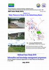
According the MRC's Basin Development Plan(BDP Sub-area Scenario), Sebanhieng Basin is located th... more According the MRC's Basin Development Plan(BDP Sub-area Scenario), Sebanhieng Basin is located the 4L in Lao PDR throughout the entire Savannakhet province and a Work plan 2010 of IKMP-Component4 will further develop modelling tools that generate data and information for forecasting, decision making, planning and impact assessment. For modeling sustainability.it is impacts of drought and flood so Sebanhieng basin have been selected for case study.Above study will use DSF model such as on the job training of ISIS and also It has been being the lesson learn about ArcSWAT(USDA), it has a challenge of a team for first time to application of LNMC Modelling team. Applications of MRC-DSF Interface has been used for low flow analysis, flood frequency analysis and a Probability Exceedence tool and there are flow simulations after water use using IQQM and ISIS flood study is also a applying in this case study.They have to update time series data reach to2008 from case study Xebanhieng2007 also sub-basin considerations. A reason that the socio-economic development in those area have been changing after Savannakhet province became Economic zone (East-West Corridor of GMS)of Lao PDR and it is critical area about water shortage (drought),deforestation and flood hazard and so on.
MK11_Applications of ESIA Government Laws such as resettlement and compensations. There are regu... more MK11_Applications of ESIA Government Laws such as resettlement and compensations. There are regulated by safeguards, Government of Lao PDR (GoL) legislations such as #192\2432\707\112 and so on. There are become to be communication tools and policy to ensure that these developments are sustainable in the long run. To explore communication and knowledge gaps and the ways of social safeguards and benefits and process to be able to improve and strengthen in villages levels. At two study areas such as Nam Ou2 and Nam Lik1 in Lao PDR. Supported by Ausaid through Challenge Program on Water &Food(CPWF) -Naga House.
A tools of Water Utilisation Programme (WUP) under the MRCS TSD were developed DSF during 2000... more A tools of Water Utilisation Programme (WUP) under the MRCS TSD were developed DSF during 2000-2006 and MRC DSF team was sett up activities such as “National Case Study” .
The Lao PDR has rich water resources , its contribution about 42% of flow is running to the Mekong river so case study number two of the year 2008 is sellected Xekong River Basin which it is situated South of Lao PDR which is a branch of Mekong River .This region is created livelihood and colorful ethnic-tribes of local for long time. The river of Xekong River Basin begins in Xekong Province, flows itself through Northern of Royal of Cambodia than Mekong River in Attapeu Province. Sekong river basin in LaoPDR is a rich natural resources in terms of in proportion to the population, with high potential for future economic growth and many potentialities for development with Sekong river basin. It is favourable for agriculture, fishery, husbandry and forestry with many rare essence, mining especially Sekong tributaries are convenient for hydropower .
Decision Support Framework (DSF) has been developed by MRC/ Halcrow and Accepted in 2004.
The Wor... more Decision Support Framework (DSF) has been developed by MRC/ Halcrow and Accepted in 2004.
The World Bank and MRCS support riparian state members (NMCs) in the application of DSF models(SWAT USDA,IQQM and ISIS).
through application national case studies. Two case studies have been selected for each member
country e.g Xebanghieng River Basin. In fact the MRC DSF was developed by Halcrow
Group Ltd(UK) at the Mekong River Commission as extension part of the Mekong Water Utilisation
Programme (WUP).accepted by MRC Join Committee and approved by MRC Council in 2004. The
capacity building on enhancement of DSF utility, the World Bank and MRCS has organized several
trainings and workshop. However, thus seems not the right way in building the capacity for National
Riparian Countries. Therefore, the support NMCs in the application of DSF through national case
studies, which directly benefit to their needs is a sufficient and was suitable method. In the year
2007, two case studies have been selected for each member country, for LNMC(Lao National Mekong Committee Secretariat), the Xebang Hieng River Basins was selected for study.
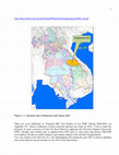
Lao PDR has been increasingly affected by natural hazards. Floods, droughts, and storms, which of... more Lao PDR has been increasingly affected by natural hazards. Floods, droughts, and storms, which often trigger secondary hazards such as landslides, fires, infestations and outbreaks of animal diseases, cause each year severe damages and losses of lives, livelihoods and infrastructure. Considering the expected impacts of climate change, these hazards are likely to increase in frequency and intensity. This creates an additional challenge for reaching the economic and social development goals and is threatening food security of smallholder farmers, who largely depend on traditional agricultural production. This research project aims to enhance research capacity of scientists using GIS flood and drought mappings in Outhoumphone and Champhone districts at the Savannakhet province of Lao PDR .
According a reference to the MOU between the IRAS project and Scenario GIS Based Flood and drought team including an Exploring Flood and Drought ”in the study areas. By applications of Rational method, SWAT model, MRC Tools Box and Decision Support Framework(DSF) for exploring flood and drought in the watershed and sub-watershed levels such as slope, groundwater, an exploring of Peak flow each water level and using tools of ArcGIS.
Chanseng Phongpachith, 2012
The Lao PDR has rich water resources its contribution about 35% of flow is running to the Mekong ... more The Lao PDR has rich water resources its contribution about 35% of flow is running to the Mekong River so case study of the year 2009 which is selected Nam Ngum River Basin. Where is provides habitats for various land cover for rubber three and Cassava plantations. Currently this basin has shown land degradation issue, agricultural practices in Nam Ngum lower basin and other activities upstream such water use for hydropower NN1, NN2, NN3, NL1&2 hydropower companies and Nam Ngum1(NN1), NN2, NN3 and NNG5 Nam Lik2 hydropower companies also increased natural resources use such as Phoubia Mining. Nam Ngum River Basin Committee (NNGRBC) who has been being practices and lesson learn and need a way of the sustainable development principle as IWRM model of Lao PDR.
This case study is explored “flow change” in observation stations from two scenario such as hydropower development and increased irrigation area. This basin is a rich natural resources in terms of in proportion to the population, with high potential for future economic growth and many potentialities for development. This watershed has a multitude of uses - agricultural, domestic, industrial, hydropower, Water use for tourism activities, fishing, navigation as well as associated cultural and spiritual values. Further development offers beneficial opportunities for the local communities, yet could also create potential conflict between upstream downstream users, as pressure on the water resources intensifies.
Nam Ngum River Basin is keeping with forest and water resources and biodiversity which existing industry of eco-tourist at the Vanvieng, Nam Ngum reservoir and along downstream of Nam Ngum river. The Nam Ngum reservoir catchment area (in this study, this reservoir catchment area refers to the study area called "Nam Ngum Watershed") is the location of the oldest Hydropower station in Lao PDR. It was constructed since 1971. Geographically Nam Ngum Watershed is located between longitudes l02º25'-l03º30' and latitudes l8º20’19º50’. The location of the study areas including Hydropower. This watershed has an area about 16,841 km2 and a length is 354Km covering four provinces: Vientiane, Xiengkhuang, Vientiane Capital, some part of Luangprabang and Borikhamsay Provinces.
There are seven National river basins of studies of Lao PDR to apply “National DSF Case” During 2006-2012 . About a sellection of basin in the case study on 2011-12, that “Nam Ngum River Basin” was priority to be aplivations of SWAT and IQQM Models where they were under the Mekong River Commision-MRC’s Decision Support Framework (DSF) for future Scenarios of water demand (Flow change). Environmental flow, expansion from irrigation area and hydropower development projects. roles of modelling for Lao technical assistants were need a upgrading skills\experiences to sustainable human resources development.

Uploads
Papers by Chanseng Phongpachith
and large-scale land-erosion on slopes and - recently - typhoons in the south. These events can be very destructive not only altering the landscape, fauna and vegetation, but also destroying public infrastructure, property, productive land, agricultural assets and harvests. The poorest people was effected, who often live in the most fragile environment and are especially reliant on climate-sensitive agriculture sector, are highly vulnerable to climate change.
UNDP and the Ministry of Agriculture and Forestry (MAF) have established at the NAFRI for the formulation of the project “Improving the Resilience of the Agriculture Sector(IRAS) in Lao PDR to Climate Change Impacts
agriculture” as part of the NAPA follow-up activities. For fighting against impact form climate change in Lao PDR such as flood and drought in target areas are consideration. Flood impact agriculture area due to population rapid grow, land use change,increasing buildings are increasingly in zones at risk of flooding. These risk zones are expected to expand in the future predict Base line scenario in 2010, Climate change scenario 2040 and2070. This results in a significant threat to residents and economic assets. Study area was sellected of is still an important part of Champhone and Outhoumphone districts, Savannakhet province.
Empirical models that provide a more simplified mathematical model of crop physiological processes and that require fewer parameters provide a more useful analytical tool for farmers, water managers, policy makers and other end-users in less developed regions where data are limited (Dourado-Neto et al. 1998; Steduto et al. 2009a). For example, if the aim of a research project is to identify and subsequently alleviate water and soil constraints to increase non rice DS crop production in Laos and Cambodia, mod els based on these principles should be considered. The Food and Agriculture Organization of the United Nations (FAO) has developed two empirical models, CropWat and AquaCrop, which could potentially fulfil these needs based on primary design function, input requirements and availability and ease of use. A third empirical model, the soil water balance model (SWBM), developed locally by the National Agriculture and Forestry Research Institute of Laos (NAFRI), University of Queensland (UQ) and the International Rice Research Institute (IRRI).
Action Plan for 2013-2020( in April 2013) and Intended Nationally Determined Contributions, these
approved by the Lao government. Both of the Strategy and Action plan on CC Management are
expected to guide central and local government agencies as well as mass organizations, the private
sector and other groups to play their parts in addressing CCA and Natural Disaster. These are also an
importanting part of the Lao PDR contribution to international CC efforts under the UNFCC.
water resources management are to
emphasize value of water resources, to provide sufficient amount of water during dry
season especially agricultural production and hydropower generation. A sustainable
development of water resources, it should be a implementing clearly Water policy
,Combination of water sectors, Human resources including research and awareness ,
implemented poor infrastructures condition of water sectors, construct National Water
Resources Management/Information System including synthetic data base, Survey water
resources in basin wide especially water shortage situations, and so on.
Lao PDR will be improved his economic conditions through development and management of water resources. In order to develop and manage water resources effectively and efficiently, what the strategies are drawn up is to be primary goal of this report.
Collaboration between Lao National Mekong Committee (LNMC)\PMO and Korea International Cooperation Agency (KOICA) Korea Water Resources Corporation (KOWACO)
and basin characteristics . As result, many coefficients were correlated to basin area such
as topography and nearby location.
Rainfall and runoff data are often inadequate. This insufficiency of data prompted
a number of researchers to conduct studies on the development of hydrologic models.
Rainfall and runoff records are used to calibrate and verify the models. The tank model
procedure was applied to calibrate and verify the runoff. There is an estimation of model
parameter. It is considered the outlet coefficients of the tank model for tropical river
basins, which is constructed to describe the rainfall-runoff. First study area, Nam Ngum
river basin is selected at Ban NaLuang gauging station where is observed in north Lao
PDR (Laos). Second studies, Nam Songkhram river basin is selected Ban Tha Kok Deang
is observed a gauging station where is in northeast portion of the Khorat plateau. Last
study, Utaphao river basin is selected Code of NoX-90 where is in southern Thailand.
The calibration procedure of the tank model works efficiently and can be used in
general practice such as tropical regions even Lower Mekong Basin. In the pass had eight
basins were selected in the Lower Mekong and Chao Phraya river basins such as Sirikit
Dam, LamdomYai, Srinagarin, Nam Chi basin at Ban Chot, Hoai Rai basin at Ban Non
Kiang, Nam Mae Chan at Ban Yano Mai, and Nam Mun, in Thailand and Thac Buoi and
Chu Basins , in Vietnam. The total results are twelve thus we can estimate water balance
in the tropical river basins.
stated development goals for the country and the sector and how different business models contribute to these goals. This paper investigates FDI into the agriculture sector in an attempt to understand the pros and cons of various business models, focusing on the model of land acquisition used by foreign investors and the extent to which various
business models are contributing to economic development.
According to “Livelihood Strategies”, Lao PDR has rules and regulation related livestock and animal such as i.) Referring to the Prime Minister's Decree on the organization and activities of the Ministry of Agriculture and Forestry . Actually Some 16 percent of the Gross Domestic Product of the Lao PDR arises from the livestock sector. Almost all output live animals and products. It is from traditional small scale production and about 90 per cent of all households in the country keep one or more species of livestock. Industrial or large scale production is of very minor importance even for pigs and poultry. Lao indigenous livestock are mainly kept in improving input systems, thus output is increasing agricultural production due to farmers can loan from the agricultural Promotion Bank and Policy Bank. Approximately 90 percent of rural households grow rice, with more than one-third of households reporting growing additional crops, cash and food crops. Currently a raising a increasing number of livestock is common, with cattle production becoming increasingly market-oriented in the central provinces.
natural disaster such decreasing temperature -2 degrees on the in the highlands at the north east of
the country on 25-27January2016. These impacts are being induced by observable changes in the
climate including higher than usual intensity rainfall events during the raining season and
extended dry seasons. The related risks include sudden flash-floods, landslides and large-scale
land-erosion on slopes, recently series of typhoons from the south pacific. Also This inter-annual
variability of rainfall in the region may be associated with large-scale climate drivers such the El
Nino-Southern Oscillation (ENSO) as well as climate change.The overall effect has been to delink long established interdependencies between farming
and ecosystems, to reduce diversity in crop varieties and production techniques, leading to even
greater vulnerability to climate risks. In order to promote resilience in the agricultural sector Lao
PDR needs assistance in improving the knowledge base on climate change, strengthening
agriculture and rural sector policies and developing institutional capacities so that systematic
adaptation planning can be carried out. At the same time appropriate and adaptive agricultural
practices need to be introduced on the ground together with measures to introduce alternative
livelihood options for poor rural communities. In order to promote resilience in the agricultural
sector and enable informed decision-making, the existing knowledge base on CC and impacts in
Lao PDR will be strengthened, specifically as it relates to agricultural production, food security
and vulnerability. The capacities of sectoral planners at national, provincial, district kumban levels
will be strengthened to understand and address climate change related risks to local food
production.
The Lao PDR has rich water resources , its contribution about 42% of flow is running to the Mekong river so case study number two of the year 2008 is sellected Xekong River Basin which it is situated South of Lao PDR which is a branch of Mekong River .This region is created livelihood and colorful ethnic-tribes of local for long time. The river of Xekong River Basin begins in Xekong Province, flows itself through Northern of Royal of Cambodia than Mekong River in Attapeu Province. Sekong river basin in LaoPDR is a rich natural resources in terms of in proportion to the population, with high potential for future economic growth and many potentialities for development with Sekong river basin. It is favourable for agriculture, fishery, husbandry and forestry with many rare essence, mining especially Sekong tributaries are convenient for hydropower .
The World Bank and MRCS support riparian state members (NMCs) in the application of DSF models(SWAT USDA,IQQM and ISIS).
through application national case studies. Two case studies have been selected for each member
country e.g Xebanghieng River Basin. In fact the MRC DSF was developed by Halcrow
Group Ltd(UK) at the Mekong River Commission as extension part of the Mekong Water Utilisation
Programme (WUP).accepted by MRC Join Committee and approved by MRC Council in 2004. The
capacity building on enhancement of DSF utility, the World Bank and MRCS has organized several
trainings and workshop. However, thus seems not the right way in building the capacity for National
Riparian Countries. Therefore, the support NMCs in the application of DSF through national case
studies, which directly benefit to their needs is a sufficient and was suitable method. In the year
2007, two case studies have been selected for each member country, for LNMC(Lao National Mekong Committee Secretariat), the Xebang Hieng River Basins was selected for study.
According a reference to the MOU between the IRAS project and Scenario GIS Based Flood and drought team including an Exploring Flood and Drought ”in the study areas. By applications of Rational method, SWAT model, MRC Tools Box and Decision Support Framework(DSF) for exploring flood and drought in the watershed and sub-watershed levels such as slope, groundwater, an exploring of Peak flow each water level and using tools of ArcGIS.
This case study is explored “flow change” in observation stations from two scenario such as hydropower development and increased irrigation area. This basin is a rich natural resources in terms of in proportion to the population, with high potential for future economic growth and many potentialities for development. This watershed has a multitude of uses - agricultural, domestic, industrial, hydropower, Water use for tourism activities, fishing, navigation as well as associated cultural and spiritual values. Further development offers beneficial opportunities for the local communities, yet could also create potential conflict between upstream downstream users, as pressure on the water resources intensifies.
Nam Ngum River Basin is keeping with forest and water resources and biodiversity which existing industry of eco-tourist at the Vanvieng, Nam Ngum reservoir and along downstream of Nam Ngum river. The Nam Ngum reservoir catchment area (in this study, this reservoir catchment area refers to the study area called "Nam Ngum Watershed") is the location of the oldest Hydropower station in Lao PDR. It was constructed since 1971. Geographically Nam Ngum Watershed is located between longitudes l02º25'-l03º30' and latitudes l8º20’19º50’. The location of the study areas including Hydropower. This watershed has an area about 16,841 km2 and a length is 354Km covering four provinces: Vientiane, Xiengkhuang, Vientiane Capital, some part of Luangprabang and Borikhamsay Provinces.
There are seven National river basins of studies of Lao PDR to apply “National DSF Case” During 2006-2012 . About a sellection of basin in the case study on 2011-12, that “Nam Ngum River Basin” was priority to be aplivations of SWAT and IQQM Models where they were under the Mekong River Commision-MRC’s Decision Support Framework (DSF) for future Scenarios of water demand (Flow change). Environmental flow, expansion from irrigation area and hydropower development projects. roles of modelling for Lao technical assistants were need a upgrading skills\experiences to sustainable human resources development.