Books by Klára Pusztainé Fischl
Die Reihe "Universitätsforschungen zur prähistorischen Archäologie" trägt dem Bedürfnis Rechnung,... more Die Reihe "Universitätsforschungen zur prähistorischen Archäologie" trägt dem Bedürfnis Rechnung, Examensarbeiten und andere Forschungsleistungen in die Öffentlichkeit zu tragen. Thematisch findet darin die ganze Breite des Faches vom Paläolithikum bis zur Archäologie der Neuzeit ihren Platz. Ursprünglich hatten sich fünf Universitätsinstitute in Deutschland zur Herausgabe der Reihe zusammengefunden, der Kreis ist inzwischen deutlich größer geworden. Alle interessierten Professoren und Dozenten sind eingeladen, als Mitherausgeber tätig zu werden und Arbeiten aus ihrem Bereich der Reihe zukommen zu lassen. Für die einzelnen Bände zeichnen jeweils die Autoren und Institute ihrer Herkunft, die im Titel deutlich gekennzeichnet sind, verantwortlich. Sie erstellen eine druckfertig gestaltete Datei (PDF). Bei gleicher Anordnung des Umschlages haben die verschiedenen beteiligten Universitäten jeweils eine spezifische Farbe. Finanzierung und Druck erfolgen entweder durch sie selbst oder durch den Verlag Dr. Rudolf Habelt GmbH, der in jedem Fall den Vertrieb der Bände sichert. Herausgeber sind derzeit:
Tell ist ein arabisches Wort, es bedeutet Hügel. In der europäischen Literatur wird es für die Be... more Tell ist ein arabisches Wort, es bedeutet Hügel. In der europäischen Literatur wird es für die Benennung von mehrschichtigen Siedlungen verwendet. Der Ursprung der Entstehung eines Teils -d.h. eines Siedlungshügels -ist, dass eine menschliche Gemeinschaft aus bestimmten natürlichen, sozialen, geistigen oder wirtschaftlichen Gründen über einen langen Zeitraum auf einem gegebenen Ort wohnt. Im Laufe der Zeit werden die Gebäude an demselben Platz immer wieder neu aufgebaut und die Reste des alltäglichen Lebens ringsum abgelagert, so erhöht sich allmählich das Wohnniveau und eine mehrschichtige Siedlung entsteht.
Leletanyag: 12. szelvény, 80-110 cm: 314. Barna színű, cserépzúzalékkal és homokkal so ványított,... more Leletanyag: 12. szelvény, 80-110 cm: 314. Barna színű, cserépzúzalékkal és homokkal so ványított, hordozható tűzhely, vagy állvány lekerekített sarkú, téglalap átmetszetü, íves tartólába. Ltsz.: 2002.16.86.2. 315. Barna-szürke foltosra égetett, cserépzúzalékkal és homokkal soványított, díszített oldaltöredék, melyen körbefutó hasi borda és ahhoz csatlakozó bekarcolt vo nalból, bordából, majd bekarcolt vonalból, kannelurából és újabb bekarcolt vonalból kialakított füzérminta látható.
Felelős kiadó: VERES LÁSZLÓ Készült: Tipo-Top Kft. Nyomdaüzemében, Miskolc Felelős vezető: SOLYMO... more Felelős kiadó: VERES LÁSZLÓ Készült: Tipo-Top Kft. Nyomdaüzemében, Miskolc Felelős vezető: SOLYMOSI RÓBERT
Papers by Klára Pusztainé Fischl
Our paper aims to provide analysis on the topography, settlement structure and land usage of the ... more Our paper aims to provide analysis on the topography, settlement structure and land usage of the archaeolog-
ical sites Vatta-Testhalom, Vatta-Dobogó (Vatta site 1) and Vatta-Telek-oldal-dűlő (Vatta site 3). The site has
been a subject of research for quite some time, although because of a misinterpreted piece of information it
was considered to be long destroyed. However due to operations by the Bükkábrány Mine of the Mátra Power
Station requiring rescue excavations, a series of aerial photography made during fortunate soil conditions and
the systematic survey work in southern Borsod Plain by the BORBAS project put our previous knowledge of
the Bronze Age site into a brand-new perspective, which is compiled in this publication.
STUDIA HERCYNIA XXIII/2, 173–197, 2019
The chronological system established by Paul Reinecke played a significant role in developing a c... more The chronological system established by Paul Reinecke played a significant role in developing a chronological classification of the Hungarian Bronze Age. However, the relative chronology which is currently being used for the Early and Middle Bronze Age by the majority of Hungarian scholars is based on István Bóna’s temporal sequence. Although Bóna’s relative chronology is still regarded as the ‘lingua franca’ in Hungary, several attempts have been made to synchronise Bóna’s relative chronological system of the Hungarian Bronze Age
with the Reinecke scheme in the last two decades. The present paper compares the two relative chronological systems and highlights some common cornerstones, supported by the most recent AMS 14C dates from the Carpathian Basin.
The paper undertakes to present the non-destructive research carried out on the Neolithic hill of... more The paper undertakes to present the non-destructive research carried out on the Neolithic hill of Mezőkeresz-
tes-Lapos-halom. The site is a settlement hill that can be connected to the late period of the ALPC (Alföld
Linear Pottery Culture), its stratigraphic conditions are not yet clear though. Based on geophysical surveys, it
is a densely built-up area surrounded by an artificial boundary line. Typologically, the northern Szakálhát and
the finds of the former Szilmeg group are closest to those presented here, and some features already point in
the direction of the Late Neolithic Period. Data suggesting an artificial landscape around the site demonstrate
conscious use of space.
Hogyan kerülhetünk a tárgyi kultúrán keresztül közelebb a bronzkori ember gondolkodásához? A fent... more Hogyan kerülhetünk a tárgyi kultúrán keresztül közelebb a bronzkori ember gondolkodásához? A fent említett idő-szakban egy-egy fontos lelőhelyről elnevezett kultúra, az úgynevezett hatvani és a füzesa-bonyi kultúrák a Kár-pát-medencei bronzkor meghatározó szereplő-ivé váltak, lényegében egy időben a Trójában feltárt III-VI. városok létezésével, s megelőz-ve a mükénéi civilizáció felvirágzását. E kultúrák egyik jellegzetessége, hogy lakódombokat, úgynevezett telltele-püléseket hoznak létre. Ez a települési forma elsősorban a Közel-Keletre és a mediterrán világra jellemző, elter-jedésének északi határa pedig a Kár-pát-medence. A házak favázas felmenő falait sárral tapasztják be. Ez a sárréteg a házak pusztulása során kiéghet. Ezt a kiégett agyagtapasztást paticsnak nevezzük. Az épületeket pusztulásu-kat követően az előző ház maradvá-nyainak elegyengetése után azonos helyen építik fel. Így az egymás felett álló épületek romjai lassan mestersé-ges dombot hoznak létre. Az éppen álló épület az elődei ledőlt falain, le-sározott padlóján és a benne maradt használati tárgyakon található. A lakótér te-hát nem horizontálisan, hanem vertikálisan nö-vekszik. Az így létrejött lakódombok akár 4 mé-ter magasak is lehetnek, és többnyire megőrzik számunkra a bronzkori házak építészeti tech-nikáját, a mindennapi élet tárgyait, az egykori ételek maradványait, a napi tevékenységek (élelmiszer-előállítás, szövés-fonás, kő-vagy agancseszköz készítés, fémöntés) nyomait. A telltípusú települések meghatározó elemei a tájnak, hiszen messzi-ről látható magas dombok, melyeket számos esetben a későbbi kor embere is használt temetkezőhe-lyül, templomok emelésére, s esetleg határjelként. Egyes elképzelések szerint a bronzkori közös-ségek is pont azért ala-kították úgy életterüket, hogy felfelé emelkedjenek, hogy a környező lakók szá-mára jelezhessék létüket a tájban. Más elképzelések szerint az ősökhöz való ragaszkodás volt az az ok, amiért mindig azonos helyen álltak az épületek. Egyes esetekben azonban a rendelkezésre álló száraz terület ha-tározta meg a település kialakításának ilyen módját. Ha madártávlatból nézzük a dél-borsodi síkság tell-vagy telljellegű településeit, megfigyelhetjük, hogy az egykor itt élt emberek a maitól el-térően alakították lakóhelyüket. A tele-pülések kör alakúak. Az egykori telepü-lésekről készült légifelvételeken látszó világosszürke foltok az egykor inten-zíven lakott zóna kémiailag módosult talaját mutatják számunkra. A belső, kör alakú teret minden esetben egy nagy és széles árok veszi körül, mely akár 6 méter mély és 20 mé-ter széles is lehetett-a légifelvételeken ezt sötét, gyűrű alakú sáv jelzi. Ezt egy hasonlóan intenzíven használt gyű-rű veszi körül, ami több esetben lóhere alakúan tagolt. Néhány olyan példánk is van, ahol ezen a gyűrűn kívül koncent-rikus kör alakban kisebb intenzívebb lakófoltok is kimutathatók. A bronzkori tele-pülések terepbejárással, felszíni leletgyűjtéssel történő vizsgálata során azonban a világos, intenzív használatra A Kárpát-medencében a Kr. e. 2300 és 1500 között élt embe-rek, embercsoportok életéről csak a hátraha-gyott anyagi kultúrájuk töredékén keresztül szerezhe-tünk tudomást. Nem ismerjük nyelvüket, nincsenek róluk írásos források, nem tudhatjuk neveiket vagy isteneik nevét. Az anyagi kultúrán keresztül bizonyos szinten azonban van lehetőség közelebb kerülni mindennapjaikhoz, társadalmuk belső felépítéséhez, sőt gondolataik egy részéhez is. Azért, hogy egyszerűbb legyen be-szélni róluk, a kutatás bevezette a régészeti kultúra fogalmát, melynek segítségével tárgyaik formai hasonlóságán, temetkezési szokásaik egy-ségességén, települési szabályszerűségeiken keresztül mesterséges egységeket hoztunk létre. Azt, hogy ezek az egységek, kultúrák milyen viszonyban voltak az egykori közösségek önmagukról alkotott képével, igen nehéz megmondani. A régészeti kul-túrák fantázianeveiket gyakran egy híres vagy elsőként felfedezett lelőhelyről, esetleg az általuk hasz-nált tárgyak jellemző formájáról vagy díszítéséről kapják.
The focus of this paper is a comparison of the dynamics of the tell periods in the Carpathian Bas... more The focus of this paper is a comparison of the dynamics of the tell periods in the Carpathian Basin and the Eastern
Balkan region. Discussed are the theories about the causes of the emergence and the abandonment of tell settlements
in both regions. As a result, a theory is developed, according to which the abandonment of the tell tradition in one
region corresponds with the emergence of tell sites in the other. Different historical research hypotheses for the for-
mation and the end of the tell settlements are presented here.
Die Reihe "Universitätsforschungen zur prähistorischen Archäologie" trägt dem Bedürfnis Rechnung,... more Die Reihe "Universitätsforschungen zur prähistorischen Archäologie" trägt dem Bedürfnis Rechnung, Examensarbeiten und andere Forschungsleistungen in die Öffentlichkeit zu tragen. Thematisch findet darin die ganze Breite des Faches vom Paläolithikum bis zur Archäologie der Neuzeit ihren Platz. Ursprünglich hatten sich fünf Universitätsinstitute in Deutschland zur Herausgabe der Reihe zusammengefunden, der Kreis ist inzwischen deutlich größer geworden. Alle interessierten Professoren und Dozenten sind eingeladen, als Mitherausgeber tätig zu werden und Arbeiten aus ihrem Bereich der Reihe zukommen zu lassen. Für die einzelnen Bände zeichnen jeweils die Autoren und Institute ihrer Herkunft, die im Titel deutlich gekennzeichnet sind, verantwortlich. Sie erstellen eine druckfertig gestaltete Datei (PDF). Bei gleicher Anordnung des Umschlages haben die verschiedenen beteiligten Universitäten jeweils eine spezifische Farbe. Finanzierung und Druck erfolgen entweder durch sie selbst oder durch den Verlag Dr. Rudolf Habelt GmbH, der in jedem Fall den Vertrieb Foreword Distribution of the OFCC sites discussed in this volume.
Kivonat 2018. június 7-9 között került sor Miskolcon a Settlement layouts, systems and structure ... more Kivonat 2018. június 7-9 között került sor Miskolcon a Settlement layouts, systems and structure of the Otomani-Füzesabony Cultural Complex (a továbbiakban OFCC) című nemzetközi konferencia megrendezésére. A konferencián az OFCC területét érintő öt ország kutatói mutatták be településkutatásaikat. A jelen kötet a konferencián elhangzott előadások egy részét tartalmazza. A bevezető tanulmány a konferencia és a kötet célját és felépítését járja körül.
Given its geographical characteristics (i.e. open to the south), the Carpathian Basin formed an i... more Given its geographical characteristics (i.e. open to the south), the Carpathian Basin formed an integral unit
with the northern Balkan regions. Previous prehistoric research highlighted the southern and southeastern connections
of these Carpathian/northern Balkans areas due to their primary focus upon Near Eastern and Eastern Mediterranean
territories and because of their chronological connections and the role played in the process of Neolithisation. In fact,
the Carpathian Basin became an active innovation centre of Central European interaction during the Early and Middle
Bronze Age with relatively loose connections towards the Aegean. Social complexes east and west of the Danube
produced different cultural and metallurgical characeristics as well as indications of different regulations of settlement
structure. However, the overall picture of the Carpathian Basin suggests the presence of the same developmental rhythm
between the 18th and 16th centuries BC. Intensive network connections are indicated by the presence of raw materials,
finished products and their replicas principally along the major rivers and tributaries which join the Danube (which
itself acted as the main northwest-southeast artery in the broader Central European region). The present paper has
briefly discusses the region’s cross-cultural networks both on a regional and interregional scale.

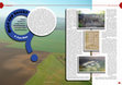
In this paper the results of an intensive survey programme are discussed carried out on the Early... more In this paper the results of an intensive survey programme are discussed carried out on the Early to Middle Bronze Age site of Tard-Tatárdomb on the foothills of the Bükk mountains. This work is part of a joint project that seeks to provide more detailed information on the multi-layer tell or tell-like sites of the Hatvan and Füzesabony periods in northern Hungary than was hitherto available. Starting on the micro-level it is our aim to explore the inner structure of these settlements, to establish the location and the structure of households, to establish if there are settlement parts with specialised function, and to compare the architecture and activity patterns of the various parts of these sites. On a macro-level an attempt is made to define the factors that determined the choice of site location and to understand the spatial organisation of settlement in environmental, economic and social terms. In the long-run, it is asked what role the sites examined had to play in the settlement network of the Hatvan and Füzesabony cultures, and an attempt will be made at comparing the land use, economy and society of both groups. To this end, our current research is based mainly on intensive archaeological survey, aerial photography, topographical measurements and magnetometer survey that provide important data both on the intra-and off-site level. In this paper we discuss the spatial data obtained by aerial photography and magnetometry as well as the results of our intensive surface survey including aspects of lithic raw material procurement and the evidence from animal bone finds.
In this paper we want to present some results of an intensive survey programme on the Bronze Age ... more In this paper we want to present some results of an intensive survey programme on the Bronze Age settlements of Emőd-Nagyhalom and Tard-Tatárdomb in Northern Hungary. The inner cores of these multi-layer sites are just one part of a more complex whole. They are surrounded by an outer settlement that is separated by a deep and wide ditch from the inner tell part. The outer settlement itself can be divided in two parts: There is an intensively used inner part probably with houses and an outer part featuring pits that could be indicative of an everyday activity zone of some kind such as storage or production. The precise chronological and functional relation of these settlement parts will be the subject of future work. Our current research is based mainly on intensive archaeological survey, aerial photography, topographical measurements and magnetometer survey that provide important data both on the intra and off-site level. This paper focuses on the results of the geophysical survey methods.
Kivonat A hatvani és a füzesabonyi kultúra települései a Borsodi síkságon és a Hernád mentén azon... more Kivonat A hatvani és a füzesabonyi kultúra települései a Borsodi síkságon és a Hernád mentén azonos belső szerkezetet és formát mutatnak. Térstuktúrájuk alapeleme egy központi, kiemelkedő -talán többrétegű -települési rész, melyet mély és széles árok vesz körül. E körül egy szintén kiemelkedő, koncentrikusan szervezett tér található, mely kutatásaink alapján intenzíven használt és lakófunkcióval rendelkezett. A legkülső, szintén a középpont köré rendeződő egység, kevésbé intenzív leletanyaggal jellemezhető. A füzesabonyi, illetve a késő hatvani kerámiák díszítőmotívum-kincsében gyakran találkozunk koncentrikus szerkezetű, középen kiemelkedő bütyökből, körülötte pedig lencséből vagy többszörös kannelúrából álló összetett mintákkal. Hasonló "díszítőmotívumokat" -feltehetően jelentéssel bíró képi elemeket -találhatunk a korszak reprezentatív bronztárgyain is. Dolgozatunkban a kör-koncentrikus kör, mint képi elem/szimbólum jelentéstartalmának megközelítését tűztük ki célul, illetve arra kerestünk magyarázatot, hogy milyen szinten határozta meg ez a forma és szimbólum a korabronzkor végi, középsőbronzkori közösségek gondolkodásmódját.
In this paper we want to provide a brief introduction to our current research on the Early to Mid... more In this paper we want to provide a brief introduction to our current research on the Early to Middle Bronze Age (Hatvan to Füzesabony period) settlement sites in the Borsod plain of North-eastern Hungary. Our work is based on intensive archaeological surface survey, aerial photography, topographical measurements and magnetometer survey that provide important data both on the intra and off-site level. With the results obtained so far, it is possible to provide a much more nuanced picture of both the internal structure of the tell and tell-like Bronze Age sites of our study area and their development through time than was hitherto possible. As an example of the ongoing research we will discuss some results of our work at the site of Tiszabábolna-Fehérlótanya including the surface finds, magnetometry and archaeozoological results.
A pilinyi kultúra bárcai csoportja -die Bárcaer Gruppe der Pilinyer Kultur. HoMÉ 4 (1964) 7-36. A... more A pilinyi kultúra bárcai csoportja -die Bárcaer Gruppe der Pilinyer Kultur. HoMÉ 4 (1964) 7-36. A tiszaszederkényi későbronzkori raktárlelet -Der Tiszaszederkény Hortfund aus der Spätbronzezeit. HOMÉ 4 (1964) 37-43. K. Végh K.-K. t.: A Herman ottó Múzeum leletmentései és ásatásai az 1959 . évben. HoMÉ 4 (1964 233-242. A péceli kultúra újabb emberalakú urnalelete Centeren -neuere Menschenförmige urnen der Péceler Kultur in Center. HoMK 6 (1964) 10-14. Jósa, A.-K. t.: Bronzkori halmazleletek -depotfunde aus der Bronzezeit. JAMÉ 6-7 (1964) 29-45.

Uploads
Books by Klára Pusztainé Fischl
Papers by Klára Pusztainé Fischl
ical sites Vatta-Testhalom, Vatta-Dobogó (Vatta site 1) and Vatta-Telek-oldal-dűlő (Vatta site 3). The site has
been a subject of research for quite some time, although because of a misinterpreted piece of information it
was considered to be long destroyed. However due to operations by the Bükkábrány Mine of the Mátra Power
Station requiring rescue excavations, a series of aerial photography made during fortunate soil conditions and
the systematic survey work in southern Borsod Plain by the BORBAS project put our previous knowledge of
the Bronze Age site into a brand-new perspective, which is compiled in this publication.
with the Reinecke scheme in the last two decades. The present paper compares the two relative chronological systems and highlights some common cornerstones, supported by the most recent AMS 14C dates from the Carpathian Basin.
tes-Lapos-halom. The site is a settlement hill that can be connected to the late period of the ALPC (Alföld
Linear Pottery Culture), its stratigraphic conditions are not yet clear though. Based on geophysical surveys, it
is a densely built-up area surrounded by an artificial boundary line. Typologically, the northern Szakálhát and
the finds of the former Szilmeg group are closest to those presented here, and some features already point in
the direction of the Late Neolithic Period. Data suggesting an artificial landscape around the site demonstrate
conscious use of space.
Balkan region. Discussed are the theories about the causes of the emergence and the abandonment of tell settlements
in both regions. As a result, a theory is developed, according to which the abandonment of the tell tradition in one
region corresponds with the emergence of tell sites in the other. Different historical research hypotheses for the for-
mation and the end of the tell settlements are presented here.
with the northern Balkan regions. Previous prehistoric research highlighted the southern and southeastern connections
of these Carpathian/northern Balkans areas due to their primary focus upon Near Eastern and Eastern Mediterranean
territories and because of their chronological connections and the role played in the process of Neolithisation. In fact,
the Carpathian Basin became an active innovation centre of Central European interaction during the Early and Middle
Bronze Age with relatively loose connections towards the Aegean. Social complexes east and west of the Danube
produced different cultural and metallurgical characeristics as well as indications of different regulations of settlement
structure. However, the overall picture of the Carpathian Basin suggests the presence of the same developmental rhythm
between the 18th and 16th centuries BC. Intensive network connections are indicated by the presence of raw materials,
finished products and their replicas principally along the major rivers and tributaries which join the Danube (which
itself acted as the main northwest-southeast artery in the broader Central European region). The present paper has
briefly discusses the region’s cross-cultural networks both on a regional and interregional scale.