Drafts by Patrick Shekleton

This document is Section 2 of a three-part work. This specific document covers the analysis on on... more This document is Section 2 of a three-part work. This specific document covers the analysis on one-hundred and seventeen cartographic works spanning from 1400 (#039) to 1529 AD (#155). The illustrations of the North American Baptistery (Newport Tower) within this specific grouping of 117 cartographic works were produced by nearly seventy (named) cartographers, along with numerous works produced by “Anonymous” cartographers.
------------------------------------------
Previous narrative for the collected set of three documents:
This study presents 315 cartographic works that objectively testify to Pre-Columbian exploration of the North American continental coastline and, more significantly, the awareness of the Christian baptistery constructed in the 12th century within the confines of Narragansett Bay on the eastern seaboard of North America. A short synopsis of each cartographic work is provided by the author along with image snippets that demonstrate the usage of tower icons to illustrate the baptistery. This study, due to file size restrictions, is presented in three sections: Section 1 (700 to 1384 AD), Section 2 (1400 to 1529 AD), and Section 3 (1530 to 1688 AD). A link to a spreadsheet collating the cartographic works is provided at the end of Section 1. The historical cartographic record testifies that the North American Baptistery (Newport Tower) was on the North American landscape in the 12th century.
Section 1, Google Drive PDF: https://drive.google.com/file/d/1vnoKQSyKG9WYEiuNeXzRQ5iT53aL8YDF/view?usp=sharing
Section 2, Google Drive PDF: https://drive.google.com/file/d/1fYNpFQlhNLIREJUXZCU0VXxE2-qPT4lg/view?usp=sharing
Section 3, Google Drive PDF: https://drive.google.com/file/d/1A8EA1N3rSYa7zhhFSz9weyYJwi4WfAhm/view?usp=sharing
MS Excel Spreadsheet (Record listing): https://docs.google.com/spreadsheets/d/1ogDqZENB042cI4UjreWJXoEbf46oZwzp/edit?usp=sharing&ouid=116070484337093837945&rtpof=true&sd=true
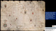
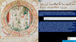
1569 Gerardus Mercator // [Nova et aucta orbis terrae descriptio…]
-Atlas 51, Maritime Museum Rot... more 1569 Gerardus Mercator // [Nova et aucta orbis terrae descriptio…]
-Atlas 51, Maritime Museum Rotterdam (Rotterdam, NL)
-GE A-1064 (RES), Bibliothèque nationale de France (Paris, FR)
-C.29.c.13, British Library (London, EN)
This Revision A presentation corrects errors and expands the analysis of Gerardus Mercator’s 1569 World Map.
Only two full-sized, original versions of this world map survive. The best version of the surviving map resides at the Maritime Museum Rotterdam. This institution (Marcel Kroon assisting) graciously provided the author with high-resolution images of the Greenland and North America sheets. The Bibliothèque nationale de France holds the other surviving full-sized version of the map. The British Library holds two sheets of the original map, one of these sheets illustrating Greenland.
On his 1569 map, Mercator continued the tradition of illustrating a proxy-placement of the North American Baptistery (Newport Tower) on the northeastern coast of Greenland. For predecessors of this illustrative placement with Greenland illustrated, see Claudius Clavus (1427), Nicolaus Germanus (ante 1467, 1481a, 1481b), Martellus Germanus (1480-1500, c. 1491), and Mercator (1541). Mercator’s 1541 globe grouped ALBA, SOTOS[T]OBA, and MARGASTER at the 72.45° latitude on, or adjacent to, the northeastern coast of Greenland. This was a 72° Elevation placement.
On his 1569 work, Mercator retained the ALBA and MARGASTER features, but renamed SOTOS[T]OBA to S: THOME CENOBIUM. The toponym shift identified the monastery described by Nicolò Zeno in his 1558 Narrative and illustrated on his 1558 Map and Atlas. On his 1569 map Mercator positioned the monastery at 74.80° latitude, a departure from the 72.45° latitude position seen on his 1541 globe. Mercator attempted to correct the latitude departure on his 1569 work (BnF map only) by including a hand-drawn feature, slightly lower in latitude at 74.00°, on the island of MARGASTER.
This hand-drawn feature was composite in arrangement. Viewed one way and a rounded hill presents. Rotate the view and one discerns a rectangular tower icon with projecting poles nestled against the hill. Mercator’s tower icon/hill arrangement carries forward the illustrative scheme of the monastery seen on both the 1558 Zeno Map and the Atlas, which positioned the monastery at the top of an multi-tiered elevation.
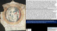
Mercator’s latitude adjustment on his 1569 map down to 74° using MARGASTER most certainly did not intersect the 72° latitude. Mercator’s hand-drawn illustration was placed at the very southern end of MARGASTER. For Mercator to have placed the hand-drawn feature at 72° latitude, he would have had to place his illustration in the ocean – something that Mercator did not do.
It was challenging to determine if Mercator crafted a tower icon illustration on the North American landform that represented the baptistery. Potentially, he traced an icon on the island of CLAUDIA – but the presentation is too weak to make this a decisive determination on this. Mercator placed CLAUDIA to east of the twin-forked RIO GRANDE in the NOROMBEGA region, an arrangement seen on later cartographic works produced by Abraham Ortelius and John Dee.
Further to the west on the coastline, around the ‘turn of the coast’ and then to the south, one finds a white-pigmented, rectangular form tucked into a bay at 39.39° latitude. This bay was toponym-assigned as BUENA VISTA. This bay was immediately south of MONTAGNES VERDE and RIO DE BUENA MADRE. There are discrete pigment shifts within the rectangular form and on the adjacent shoreline of the bay that strongly suggests that Mercator was using his instrument to purposefully craft miniature features.
To affirm the tower icon illustration within the BUENA VISTA bay, Mercator fashioned an offset-longitude illustration of the North American Baptistery (Newport Tower) out in the ocean far distant from the North American landform, on his latitude scale. Using white pigment, Mercator crafted a miniature rectangular form that he attached to the upper part of the number “0” in the “40” designation of a latitude parallel. Adjacent to this feature, within the latitude bar itself, Mercator then used white pigment to craft multiple tower icons.
Gerardus Mercator is rightfully extolled for the origination of the new cartographic projection scheme that bears his name (the Mercator projection). He is wrong vilified by cartographic historians for adopting the illustrative elements related to the 1558 Nicolò Zeno Map and Atlas. This latter criticism is unwarranted and historically incorrect.
Mercator’s Greenland illustrations, like Zeno’s, were a continuation of cartographic tradition (a proxy-location of the North American Baptistery (Newport Tower)) that had existed, in part, since the 13th century, and explicitly with Greenland being illustrated since the 15th century. Mercator’s Frisland illustration was the adoption of another cartographic tradition, first arising in the 15th century, well prior to Zeno employing it in his Narrative, Map, and Atlas.
Mercator’s GROCLAND was unique. GROCLAND traces back to the historical account of the Inventio Fortunatæ. The Inventio Fortunatæ encapsulated the 1350s/1360s exploration of the Northern Regions of the Atlantic Ocean. GROCLAND represented North America.
This presentation contains 125 slides.
Google Drive PowerPoint (282.5 MB): https://docs.google.com/presentation/d/1N1rRWKw2f61GXc68xn9zFUDhR_eZSK-5/edit?usp=sharing&ouid=116070484337093837945&rtpof=true&sd=true.
Google Drive PDF (30.9 MB): https://drive.google.com/file/d/10_ZN_9HTPfgr-7g7JeE7u7W6uDKMEv-6/view?usp=sharing
Microscopic Analysis
1665 João Teixeira Albernaz (Portugal) // [Portolan Chart of the Atlantic…],... more Microscopic Analysis
1665 João Teixeira Albernaz (Portugal) // [Portolan Chart of the Atlantic…], Call Nbr 11 1665 // Beinecke Rare Book and Manuscript Library Yale University (New Haven, CT)
In 1665, the noted Portuguese cartographer João Teixeira Albernaz finished the last cartographic work produced in his lifetime. Albernaz, a prolific cartographer, had produced earlier in his lifetime a significant quantity of works that primarily focused on South America. In this last work of his he illustrated North America, along with the Atlantic Ocean extending back to Europe. In the mid-Atlantic Ocean Albernaz fixed an internal latitude scale. On the eastern side of this scale he illustrated the full inventory of islands of the Azores. On the western side of the scale at 41.50° latitude, he illustrated a cross with a dot in each quadrant, this symbol representing the eighth day – the Ogdoad. In Christianity, the Ogdoad is associated with Easter Sunday, the day of Jesus’s resurrection, and the day when the rite of baptism was administered to those entering the Christian faith. He assigned the truncated toponym of VI[R]GIN to the Ogdoad symbol. The “Virgin” was a reference to the Blessed Mother Mary. On the lower loop of the letter “G” in VI[R]GIN he illustrated a tower icon – the Newport Tower in an offset-longitude placement, but set at 41.00°. Under microscopic analysis, the larger tower icon feature, rectangular in form, was rendered with red pigment. Using the same red pigment Albernaz stroked a short pole and affixed a very rough square flag.
The interior of this larger tower icon feature contains a secondary tower illustration, a two pillar structure. Albernaz crafted this through his arrangement of the red pigment.
Albernaz reached back in time, into the vault of history, for this 41.00° tower icon illustration and 41.50° Ogdoad symbol illustration, The 41.50° latitude was the location of the paired islands in what has been described as the “False Azores.” The paired islands, toponym assigned as CORVI MARIM and LICO NIGI, were first seen on the 1375 “Catalan Atlas” of Abraham Cresques. MARIM is Mary.
The cartographic tradition of CORVI MARIM and LICO NIGI fell into disuse after early 16th century cartographic works began to illustrate the North American coastline. CORVI MARIM transitioned – holding the same latitude – to the RIO DE BUENA MADRE toponym on the coast, which designated Narragansett Bay. BUENA MADRE, the Blessed Mother, was Mary, the Virgin.
Albernaz employed white pigment to render circular and rectangular features on the North American landscape. On the western side of the wedge-shaped Penobscot River he illustrated a rectangular, white-pigmented tower icon within a brown-pigmented stain presentation. On the west side of the Bay of Fundy, he crafted a circular feature with black pigment into which he inserted a white-pigmented, tapering rectangular form. Near the southern end of Nova Scotia on its eastern coast he crafted a patch presentation with white pigment and then inserted a rectangular, dark pigment form. A white-pigmented circle form was fixed to the southeastern coast of Newfoundland.
Albernaz’s second illustration of the North American Baptistery (Newport Tower) is within the interior of a red-pigmented island just outside of Narragansett Bay which by his internal latitude scale, sits at 42.10° latitude. Albernaz stroked two rectangular, white-pigmented tower icons in a side-by-side arrangement.
This presentation contains 47 slides.
Google Drive PowerPoint (80.8 MB): https://docs.google.com/presentation/d/1xqIw0FAlrVZZoQBaufBgQsS6ghjZ2XFX/edit?usp=sharing&ouid=116070484337093837945&rtpof=true&sd=true
Google Drive PDF (7.8 MB): https://drive.google.com/file/d/1NG28B91xsMQ37hVaxuNcdxj1dIyEzarM/view?usp=sharing
This atlas is in the holdings of the British Library in London, England. The atlas contains ... more This atlas is in the holdings of the British Library in London, England. The atlas contains thirty eight nautical charts spanning across thirty-five pages within the atlas. Iconic illustrations of the North American Baptistery (Newport Tower) are present on folios. 006r, 008r, 011r, 014r, 027r, 029r, and 030r. Digitized images of the charts are widely available on the Internet, a good source to view them in a consolidate manner is here: https://recogito.pelagios.org/document/ebmkr0i5xyhmkm/part/1/edit.
Alternately, if you wish to download all of the maps in a convenient manner (the author “found” a data folder a few years back on the BL website and downloaded it), here is the link to where the maps are stashed on the author’s Google Drive: https://drive.google.com/drive/folders/19svZCrIDNiFX7FI1eWFNLX_I7W7hJftA?usp=sharing
The Anonymous cartographer/illustrator who crafted the charts within the atlas might not ever be identified. Scholars attribute production of the atlas to Venice, Italy.
Tony Campbell, a former Map Librarian at the British Library, has studied and written about the Cornaro Atlas. Campbell’s research identified that the charts within the atlas were based upon older, and by then obsolete, cartographic works:
"One well-known instance – the British Library’s Cornaro atlas (Egerton MS. 73)-makes no attempt to disguise its use of obsolete charts. Though its thirty-four sheets of charts are apparently drawn in the same hand throughout (and one of them is dated 1489), most are acknowledged copies of the work of earlier chartmakers. Among the authors cited are Francesco Beccari and Nicolo de Pasqualini, for whom single signed works are known, dated respectively 1403 and 1408. The same intentional reproduction of out-of-date charts might help explain the conflicting drafts of the Adriatic in the Medici atlas." (Campbell 1987: 401-02)
All cartographic works “preserve” knowledge, in some fashion or another. Regressive knowledge is sometimes referred to as tradition. In the case of the Cornaro Atlas, the tradition was the illustration of tower icons to represent both the North American landform as well as the North American Baptistery (Newport Tower).
However, the atlas, on folio 30r, also established a new tradition (in a manner of speaking). This was the toponym assignment of the YNSULA DE SAN TOMAS to a red-colored island against the border margin of the western Atlantic Ocean (spanning the latitudes between 41.14° and 42.28°). The island of SAN TOMAS bracketed, in latitude, the North American Baptistery at 41.48°. The “new tradition” would not persist at this latitude, the SAN TOMAS toponym would lift off to the northeast coast of Greenland on later cartographic works (Mercator, Zeno, Ortelius, Dee, etc.), being positioned at the 72nd latitude parallel – which was a proxy-positioning using the Summer Solstice Zenith Elevation value of 72° (the Sun-God) to cross-correlate to the geodetic latitude of the 12th century constructed baptistery within Narragansett Bay at 41.48°.
There are seven charts within the Cornaro Atlas that illustrated the North American Baptistery (Newport Tower).
---------------------
Google Drive PowerPoint (213.9 MB): https://docs.google.com/presentation/d/1F4OCVBbXrBwgTyl4QmuaO6CXY6X7YNLa/edit?usp=sharing&ouid=116070484337093837945&rtpof=true&sd=true
Google Drive PDF (17.6 MB): https://drive.google.com/file/d/1LVTaIip_JVOZuTCNxM_voBkQQu2nlhP2/view?usp=sharing
On his 1507/08 World Map Johannes Ruysch assigned the toponyms of “Biggetu Insula” and “Barb... more On his 1507/08 World Map Johannes Ruysch assigned the toponyms of “Biggetu Insula” and “Barbatos Insula” to two islands outside of Narragansett Bay and below the southern coastline of the Cape Cod peninsula. Ruysch’s toponym constructs, slightly corrupted, were based on Old Norse (ON) words. As such, these toponyms provide evidence that the Norse had penetrated down to the Narragansett Bay region. Ruysch’s ‘Biggetu’ term deconstructs to ‘settlement’ and ‘eight’, thus identifying the eight-pillar stone baptistry constructed within Narragansett Bay in the 12th century.
This Revision A version removed some unneeded and overtaken-by-events (OBE) cartographic references. This paper is 28-pages in length.
Google Drive Word document (13.6 MB): https://docs.google.com/document/d/1sy5Jw_7D01edqSgcUSG4j83sZpslP9H4/edit?usp=sharing&ouid=116070484337093837945&rtpof=true&sd=true
Google Drive PDF (3.0 MB): https://drive.google.com/file/d/13TsKIZxgPOvEcrbRxqJ9o4TK9tX7jWKr/view?usp=sharing
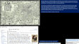
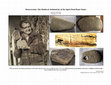
A quick analysis of the recently disclosed woodhenge in Aars, Denmark.
The American archaeologist, Carl Feagans, back on 25 January 2025, shared with his audience ... more The American archaeologist, Carl Feagans, back on 25 January 2025, shared with his audience his "recent thoughts" about the author’s published chapter, “Maximus Planudes and Piri Reis: Unusual Approaches on North America and its Baptistery.” Feagans disagreed with the assessment that the Newport Tower, a baptistery, was constructed in the 12th century. The author addresses Feagans’ criticisms in this response.
This 104-slide presentation presents an analysis of the 1448 Andrea Bianco portolan chart he... more This 104-slide presentation presents an analysis of the 1448 Andrea Bianco portolan chart held by Biblioteca Ambrosiana in Milan, IT. The analysis used a 216 MB JPG file graciously provided by the Biblioteca Ambrosiana.
1448 Andrea Bianco Portolan Chart
[Atlantic coasts of Europe and Africa from the British islands to Cabo Roxo}
F 260 Inf. (1) // Biblioteca Ambrosiana (Milan, IT)
https://medea.fc.ul.pt/view/chart/89/viewer
This is a very interesting chart, the last one produced by Bianco in his limited atelier. Bianco illustrated the North American Baptistery in two ways. The first is through the illustration of tower icons on the two islands comprising the “False Azores,” these islands toponym-labeled by Bianco as CORVO S[ANCTO] MARINAS and CORIIO[G?]. The second illustration employed by Bianco was a partial arc of a circle in the Atlantic Ocean. Complete the circle and you have CIRCLE LAND, whose northern bounds intersects the northern aspect of CORVO S[ANCTO] MARINAS and correlates to the latitude of Narragansett Bay, the location of the baptistery.
Bianco, like others before him, illustrated the proxy-longitude positioned islands of TILE, BRAZILE, and MAM. These islands all represented regions on the North American continent. Bianco illustrated features on the western margin of his chart that correlate to the latitude of Bermuda, Florida, and points south. At the southern end of his chart, Bianco illustrated a feature at the latitude of the Cape Verde Islands, then a split clamshell feature which correlates to the split-archipelago island off the coast of Conakry, Guinea (whose toponym, DOS ERMANES, traces to the term “brother,” which in turn means that DOS ERMANES is the “brother” to the Pillars of Hercules at the Strait of Gibraltar), and then he illustrated an island (IXOLA OTINTICHA/OTENTICHA). This last island was a proxy-longitude placement of an island off the coast of South America.
1448 Andrea Bianco Chart
Google Drive PowerPoint (410.7 MB): https://docs.google.com/presentation/d/1qX4eTBPK1XXsw-o9Qxi2rnaxlx3fBxoc/edit?usp=sharing&ouid=116070484337093837945&rtpof=true&sd=true
Google Drive PDF (23.5 MB): https://drive.google.com/file/d/1tc8Yj5hNHfojuMER_oqC5Mvl8jFTZnBW/view?usp=sharing
Giovanni Leardo, a Venetian cartographer, produced this map in 1448. This world map was the ... more Giovanni Leardo, a Venetian cartographer, produced this map in 1448. This world map was the second of three that Leardo produced, one prior in 1442 and one later in 1452.
…..The analysis of the 1448 Leardo World Map employed a 1200 dpi, 679 MB TIFF image file received from the Biblioteca Civica Bertoliana in Vicenza, IT. The author would like to publicly thank the Biblioteca Civica Bertoliana, and specifically Erika Zanotto, for their gracious assistance. The 1200 dpi image of the map is quite good, but it should be noted that, unfortunately, the image’s resolution trailed off when examining miniature features. This limitation is frequently pointed out on the analysis slides. Any future analysis of this map’s miniature feature should use digital microscopy.
Given that we had suitable imagery to assess features on the entirety of Leardo’s 1448 map, we did just that. However, as always, the primary focus of the analysis was to located and identify tower icons representing the North American Baptistery (Newport Tower), as well as icons that defined locations/regions in the extended North America, this region extending down into the Caribbean Sea. To this end, we were successful.
…..To allay any confusion, the term “tower icon” is used as a generic classification to identify features that represent habitations, this latter term also somewhat generic as a habitation can simply be a location that was temporary, such as a provisioning location for the seafarers. The overall point is that cartographers illustrated the extent of exploration in the Atlantic Ocean and on the North/South American continents by illustrating miniature structures. Most times the structures were represented as rectangular icons, sometimes topped with a pole.
Respective of South America, the author did not note any visually obvious features on the western edge of the ocean, or within the circles encompassing the circumference of the map in the region opposite of Africa, while examining performing this analysis. The same was true of the prior analysis of Leardo’s 1452 World Map.
Leardo most certainly was illustrating miniature tower icon features on his map – and some of them are quite small even by the definition of miniature. While Leardo produced miniature features, they are neither elegant nor done all the time with precision, the author would describe them as functionally adequate.
Leardo illustrated the North American Baptistery (Newport Tower) in four separate cases. The first two cases were illustrations on the western margin of the Atlantic Ocean (this illustration was a double-tower icon arrangement, a cityscape, with a thin vertically projecting pole at 41.5° latitude rendered using black pigment) and then a more detailed arrangement off the western edge of the map at 41.5° latitude (this being a large, white pigment arrangement). On the eastern edge of his map at 41.5° latitude within the PARADIXO TERESTA vignette, Leardo inserted a pair of rectangular forms atop the structure, these being interpreted by the author as tower icons. These rectangular features were placed at 41.5° latitude, in opposition to the baptistery icons located on, and off, the western margin of his map. Lastly, Leardo did a proxy-latitude illustration of the North American Baptistery (Newport Tower) up at 72° latitude. The 72° proxy-latitude utilized the meridian transit (Zenith Elevation of the Sun on the Summer Solstice) value, the 72° correlating to the geodetic latitude of 41.5° latitude, which thus identifies the North American Baptistery.
---------------------
Analysis
File name: 1448 Leardo WM // 142 slides
Google Drive PowerPoint (440.1 MB): https://docs.google.com/presentation/d/1KQ_oC9jSK5PPvH242EPMRc9ABOV0KOxE/edit?usp=sharing&ouid=116070484337093837945&rtpof=true&sd=true
Google Drive PDF (43.3 MB): https://drive.google.com/file/d/1mD5el-Clz87ji4Lkin3oJf2bClxP1wyG/view?usp=sharing
---------------------
The analysis generated a large number of snippet images whose file sizes created an unwieldy PowerPoint file size. Thus, the images were moved into a separate file. This file contains no analysis discussion. The images are provided for your review (and use, if you wish).
Additional imagery generated by the analysis:
File name: 1448 Leardo WM, Unused Images // 60 slides
Google Drive PowerPoint (95.3 MB): https://docs.google.com/presentation/d/1Qv12rrLoRDxgViNg9LIiBEi5Gie16VHC/edit?usp=sharing&ouid=116070484337093837945&rtpof=true&sd=true
Google Drive PDF (14.4 MB): https://drive.google.com/file/d/1ER4RxxHHuOn7Som1UB74WYc55PyhbTtN/view?usp=sharing
Giovanni Leardo, a Venetian cartographer, produced this map in 1452. This world map was the ... more Giovanni Leardo, a Venetian cartographer, produced this map in 1452. This world map was the last of three that Leardo produced, the two earlier ones dating to 1442 and 1448.
…..The analysis of the 1452 Leardo World Map employed microscopic imagery that the author obtained in November 2024 during a visit to the American Geographical Society Library at the University of Wisconsin-Milwaukee.
…..The focus of the analysis was to locate and catalogue the miniature tower icon features that Leardo rendered in the Atlantic Ocean, either as stand-alone features or situated upon island features. Additionally, tower icon features were identified on the western coast of Africa.
…..To allay any confusion, the term “tower icon” is used as a generic classification to identify features that represent habitations, this latter term also somewhat generic as a habitation can simply be a location that was temporary, such as a provisioning location for the seafarers. The overall point is that cartographers illustrated the extent of exploration in the Atlantic Ocean and on the North/South American continents by illustrating miniature structures. Most times the structures were represented as rectangular icons, sometimes topped with a pole.
Respective of South America, the author did not note any visually obvious features on the western edge of the ocean, or within the circles encompassing the circumference of the map in the region opposite of Africa, while examining the map in November 2024. Other scholars, if they put a microscope to the map in this area, or if multi-spectral imaging of this specific region is done, might have different results.
Leardo most certainly was illustrating miniature tower icon features on his map – and some of them are quite small even by the definition of miniature. While Leardo produced miniature features, they are neither elegant nor done all the time with precision, the author would describe them as functionally adequate.
The drawing instrument in his hand adequately formed the rectangular tower icon shape, sometimes with projecting poles, and at times he fashioned cityscape arrangements. He employed contrasting colors (black and white) to fashion extended cityscape features on islands. Typical of cartographers of the era, his island representations rested upon white pigment “patch” presentations, this arrangement lending both depth and outline to the islands. Leardo then illustrated tower icons on the islands (primarily using a dark color). In the Atlantic Ocean, Leardo “submerged” tower icon/island features within the blue ocean pigment as well as the gently curving red bands extending from the wind illustration – these features were quite difficult to locate even with microscopic imagery.
Leardo illustrated the North American Baptistery (Newport Tower) in a cityscape feature near the western margin of his map, placing this feature at ≈ 42° latitude within a red wind band.
---------------------
Analysis
File name: 1452 Giovanni Leardo World Map, 2Feb2025 // 94 slides
Google Drive PowerPoint (381.4 MB): https://docs.google.com/presentation/d/1s4w7C2ChSI0B4fkRFtMixMvxbUrkJYhH/edit?usp=sharing&ouid=116070484337093837945&rtpof=true&sd=true
Google Drive PDF (34.8 MB): https://drive.google.com/file/d/1Cfpf4GLHKLLX6TVCR8yaCngaF0Wjb7Ga/view?usp=sharing
---------------------
The analysis generated a large number of snippet images whose file sizes created an unwieldy PowerPoint file size. Thus, the images were moved into a separate file. This file contains no analysis discussion. The images are provided for your review (and use, if you wish).
Additional imagery generated by the analysis:
File name: 1452 Leardo W_Map_Microscope_Discards, 2Feb2025 // 52 slides
Google Drive PowerPoint (249.1 MB): https://docs.google.com/presentation/d/1BSMG6MMqLdhhqGD5A3wChw93MpezdCHL/edit?usp=sharing&ouid=116070484337093837945&rtpof=true&sd=true
Google Drive PDF (29.8 MB): https://drive.google.com/file/d/1VkagNGI3eKWQcUyDr8kLoN6N52YxkoHW/view?usp=sharing
This 84 slide presentation is a preliminary analysis of the 1436 Andrea Bianco Hybrid Mappam... more This 84 slide presentation is a preliminary analysis of the 1436 Andrea Bianco Hybrid Mappamundi held by the Biblioteca Nazionale Marciana in Venice, IT. The analysis used a 7.3. MB JPEG file taken back in August 2016.
1436 Andrea Bianco Hybrid Mappamundi within his Atlante Nautico
Ms. It. Z 76 [tav. 9, cc. 9v-10r]
Biblioteca Nazionale Marciana
https://www.movio.beniculturali.it/bnm/ridottiprocuratorisanmarco/it/118/andrea-bianco
Overall, the 7.3 MB JPEG file is adequate for a preliminary screening and a limited analysis. This map is slated to be re-imaged the week of January 26, 2025 using a 100 Mpx camera. Once that imagery is obtained and processed by the author, this presentation will be deleted and a revised version shall be shared.
Bianco illustrated – in miniature – a tremendous amount of information on his hybrid mappamundi. He illustrated several miniature icons and features in the region representing South America. Again, this is just preliminary at this point.
As everyone knows, figures and graphics within published works sometimes are sized too small... more As everyone knows, figures and graphics within published works sometimes are sized too small for the reader to adequately assess the information that the author tried to convey. The sizing of figures/graphics is a function of available space, formatting flow, and choices made by the author. As this article contained 63 figures, the author reduced the figure size to save space. The size of each submitted figure, knowing the article was going to be electronic, was judged by author to ensure both the selected size did not reduce the conveying of the detail and information.
Too small of figures/graphics within printed works are vexing, the reader has no ability to easily enlarge/expand the figure/graphic. Electronically published works overcome this limitation to a degree, as the reader can easily magnify the image. However, as nearly all electronically published articles rely upon PDF formatting, and since PDF formatting only samples the original number of pixels to achieve compression, loss of information may occur.
This is the working file for most of the figures/graphics used within the article. For the most part, the graphics in the figures have already been shared in PowerPoint presentations on Academia. The only exception to the prior sharing were the image snippets taken from the 718 MB TIFF file of the 1513 Piri Reis Map. These snippets are at the end of this presentation.
![Research paper thumbnail of 1582-1583 John Dee Map [Humfray Gylbert knight his charte]: Microscopic Analysis of Miniature Illustrative Features](https://attachments.academia-assets.com/120875491/thumbnails/1.jpg)
1582-1583 John Dee [made for]
[Humfray Gylbert knight his charte]
Elkins 42 // Free Library of Ph... more 1582-1583 John Dee [made for]
[Humfray Gylbert knight his charte]
Elkins 42 // Free Library of Philadelphia
John Dee, the famed English polymath, crafted a map (Humfray Gylbert knight his charte) which is in the holdings of the Free Library of Philadelphia. In February 2024, the author made two trips to Philadelphia to capture microscopic imagery of the map. The goal was to find a valid illustration of the North American Baptistery (Newport Tower). The effort was successful. The evidence of the tower illustration was accomplished by Dee via the use of white pigment forming two rectangles, one large and one small, within Narragansett Bay.
Dee, who was introduced to Queen Elizabeth I by the 1st Earl of Leicester, Robert Dudley, advocated that the British Empire also included North America, based on both precedent and long-standing historical claims. This map illustrated, in part, some of the historical claims (not all the claims were sound).
Dee’s illustration of the relic stone tower on this 1582-1583 map is not surprising for he illustrated the relic stone tower on two other maps, one dated to 1580 [Cotton MS Augustus I.i. 1 // British Library (London, EN)] and the second dated to c. 1582 [MS. Ashmole 1789 // Bodleian Libraries].
Had Sir Humphrey Gilbert’s ill-fated 1583 expedition to establish an English colony within Narragansett Bay (then described as “…that ryver or porte called by Master John Dee, Dee Ryver which Ryver by the descripcian of John Verrarzanus a Florentyne lyeth in Septrontrionall latitude of about fortye twoo degrees…”) succeeded, Dee would have acquired “5000 akers” of land within the sizable 1.5 million acre grant, presumably on the Dee Ryver. Unfortunately, the Gilbert expedition failed and English settlement of the “Dee Ryver” region would be postponed until 1638/1639 when the northern, then the southern, areas of Aquidneck Island were eventually settled by English colonists.
This presentation contains 143 slides.
Google Drive PowerPoint (186.4 MB): https://docs.google.com/presentation/d/1ZOlfVfTL3bZvA643jD8XMzKib9wv77gs/edit?usp=sharing&ouid=116070484337093837945&rtpof=true&sd=true
Google Drive PDF (20.2 MB): https://drive.google.com/file/d/1cILhi-lYOfkALclEm2hUtabxvQ45YNqV/view?usp=sharing
The Spirit Pond Rune Stones (SPR), four runic inscribed artifacts, were discovered in May 19... more The Spirit Pond Rune Stones (SPR), four runic inscribed artifacts, were discovered in May 1971 in Phippsburg, Maine. Walter Elliott, a handyman whose formal education ended after his sophomore year of high school, was combing the western shoreline of Spirit Pond looking for Native American arrowheads when he chanced upon the inscribed stones. The Maine State Museum (MSM) initiated an investigation into whether the artifacts were authentic, or hoaxed. Two experts were hired to examine the artifacts. Dr. William Young of the Museum of Fine Arts Boston engaged in a geologic analysis of the inscribed marks, the focus being whether evidence existed to date the marks. Dr. Young was unable to make a determination and did not generate a formal report of his findings of fact. Dr. Einar Haugen of Harvard University assessed the runic inscriptions, producing a report that concluded the inscriptions had been hoaxed. Haugen’s May 1972 report was a fair assessment for that era, however, subsequent advances in runic scholarship objectively demonstrate that Haugen’s findings were flawed – and cannot be accepted today.
In the late 1980s and the decade of the 1990s, American archaeologists – through innuendo and hearsay – came to accusing Walter Elliott as the hoaxer of the SPR, an opinion that Dr. Haugen, in his May 1972 “Confidential” report to the MSM, explicitly rejected.
The Spirit Pond Rune Stones (SPR) are authentic medieval artifacts. The four runic-inscribed stones found in May 1971 by Walter Elliott are the surviving relics of a hús-vitjan (svitlg) journey to North America and Narragansett Bay. The stones describe four geographical locations along the northeastern seaboard: the Bay of Fundy (hrinikin), the grazing land (vinnant) fronting and within the tidal inlet (hóp, hoop) at Spirit Pond (Phippsburg, Maine), the intermediate waypoint (tvau: takh) at the northern tip of Cape Cod of the sail from Spirit Pond to Narragansett Bay, and then the region of Narragansett Bay (vist: 12: nor 10) where the North American Baptistery (Newport Tower) (haladhir mirainbadhum) was located.
The journey that began in 1401 AD (1010) was ill-fated – the crew never made it home. The last scribed entry date was 1402 AD (1011), the inscribed stones abandoned on the western shoreline of Spirit Pond.
The attributes of the various inscriptions were fused with Christian elements (two versions of the Ogdoad-rune, three references to the Virgin Mary, and multiple references to the baptistery (haladhir (cave, Sepulchre), badhum (bath, cleansing), lag (lauger, Holy well)). Two terms related to Norse mythology (pagan) are present in the inscription (odin and aki (Ægir). The Christian Ogdoad, representing the Eighth Day of Easter in Christianity, traces back in history through Gnostic concepts of the heavens and the earth and other pre-Christian deities.
This work deconstructs the events surrounding the discovery, examination, and the erroneous judgement that the SPR were hoaxed artifacts. A detailed study of the runic inscriptions on each of the four stones was executed using modern day tools that did not exist in the 1970s. The scribed words, along with the infused symbolism on the artifacts, were assessed against the historical context of Medieval Era geodesy, navigation, cartography, and Christianity.
The study is presented in two files, the first being the Main Body (chapters) and the second being the Appendices.
(1) Main Body: Google Drive Microsoft Word, pp. 216 (114.7 MB): https://docs.google.com/document/d/1P1tumYtMqcqV_r6l390Xe4a_Bbb1mCVw/edit?usp=sharing&ouid=108078659971084354140&rtpof=true&sd=true
(1a) Main Body: Google Drive PDF, pp. 216 (23.4 MB): https://drive.google.com/file/d/1Yv7cz0J2dPkqyXpN_orNgP9OWo7LvoRE/view?usp=sharing
(2) Appendices: Google Drive Microsoft Word, pp. 231 (117 MB): https://docs.google.com/document/d/1eR1nuR16bioaXg8NkCgci3g8mJEcZ6dE/edit?usp=sharing&ouid=108078659971084354140&rtpof=true&sd=true
(2a) Appendices: Google Drive PDF, pp. 231 (51.6 MB): https://drive.google.com/file/d/1R8LZlg8HX4Xrx-mlrJkQyg2D4ACJNzaZ/view?usp=sharing
After Columbus “discovered” the New World the Pope issued a series of Bulls that divided the... more After Columbus “discovered” the New World the Pope issued a series of Bulls that divided the world into two commerce zones, one being awarded to Spain and the other to Portugal. The line in the Atlantic Ocean demarking the respective zones was first decreed as being 100 leagues to the west of the Canary Islands. This line was abandoned in short order, the new line being set as 370 leagues to the west of the Canary Islands by the 1494 Treaty of Tordesillas. In 1495, the Royal Cosmographer of Spain, Jaime Ferrer, wrote a letter to the Sovereigns of Spain explaining how the 370-league line west of the Canary’s could be established. Ferrer then added that if you used the navigational method just explained, which established the “true terminus” of the 370-league west of the Canary’s line, and then simply extended that course for another “three degrees and a third of latitude” you would arrive at the “western parallel.”
The Western Parallel was actually the longitude meridian which divided the world into two hemispheres. This meridian sliced between Newfoundland and Nova Scotia at approximately 60° W, referenced to Greenwich. All lands to the west of this longitude parallel were in the Eastern Hemisphere, thus the coastline of the North American continent was considered to be the land of Asia, the “home” of Prester John.
The Western Parallel (Newfoundland-Nova Scotia Prime Meridian (NF-NS PM)) was decisively established in the 1350s/1360s by the Cambridge, England-based friar John Estwood during the 14th century Inventio Fortunatæ survey explorations. This meridian was exactly 90° to the west of Alexandria, Egypt.
Runic-inscribed stones discovered in 1971 in Phippsburg, Maine, the stones being dated to 1401/1402 AD, contained geographic coordinates that referenced the NF-NS PM. The 1427 First Map of the North (Nancy Map) of the Danish monk Claudius Clavus referenced the NF-NS PM. Nicolaus Germanus, Paolo Toscanelli, and Martin Behaim all referenced the NF-NS PM (Western Parallel) on their cartographic works prior to Columbus’s 1492 “discovery” of the New World.
After Ferrer’s 1495 letter, the Western Parallel slicing between Newfoundland and Nova Scotia was illustrated on over a dozen cartographic works across the 16th and 17th centuries.
This paper totals 74 pages.
Google Drive Microsoft Word (59.7 MB): https://docs.google.com/document/d/187WktDWJ0QiKOJ-vdjzTzZeqHipjaDn-/edit?usp=sharing&ouid=108078659971084354140&rtpof=true&sd=true
Google Drive PDF (7.1 MB): https://drive.google.com/file/d/1myQPDZAtIyIv8AnfX1NBAukE4HL2I-jX/view?usp=sharing
![Research paper thumbnail of 1592 Thomas Hood Sea Chart [BSB, Cod. Icon. 140, Fol. 84], Rev. A - Cartographic Evidence of the Pre-Columbian Newport Tower](https://attachments.academia-assets.com/110736477/thumbnails/1.jpg)
Revision A of the analysis on this sea chart, which was initially analyzed by the author bac... more Revision A of the analysis on this sea chart, which was initially analyzed by the author back in March 2021, was undertaken to rework the imagery. This cartographic work would benefit from an real-time analysis using digital microscopy. Unfortunately, the map is in Germany and the author lives in the United States.
The 1592 Thomas Hood Sea Chart is held by the Bavarian State Library (BSB), Munich, Manuscripts and Rare Prints Department. Back in 2021, BSB graciously provided a superb, high-resolution snippet of the map for an analysis of the North American coastline from CAPE DE ARENAS up past the RIO DE BUENA MADRE. Thomas Hood illustrated the Newport Tower within Narragansett Bay. In addition to the Newport Tower representation, Hood quite possibly illustrated two additional structure features on the shoreline area of the bay. Between Narragansett Bay and extending south into the region of present-day New Jersey Hood's illustrated additional structures. Hood used white pigment for most of his structure illustrations. Miniature features rendered using white pigment are quite difficult to notice, thus effectively hiding from any casual observer what Hood actually did on this cartographic work.
Anthony Greb, in typical fashion, re-worked the snippet images. Steve DiMarzo collaborated with the visual analysis and captions.
This Revision A presentation contains 71 slides.
Google Drive PowerPoint (67.4 MB): https://docs.google.com/presentation/d/19jS5dehkhf9en4Ty2qNSlHnEU4yLq9uO/edit?usp=sharing&ouid=108078659971084354140&rtpof=true&sd=true
Google Drive PDF (9.3 MB): https://drive.google.com/file/d/1C-FU7n_PIRvvLtxg6uRB6pJucoEJ9w17/view?usp=sharing
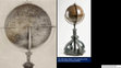
This 1542-produced, copper plate, engraved globe is held by the New York Historical Society.... more This 1542-produced, copper plate, engraved globe is held by the New York Historical Society. Euphrosynus Ulpius was an Italian artist, some sources placing him in Rome while others place him in Venice.
Ulpius illustrated the 12th century North American Baptistery (Newport Tower) adjacent to the REFUGIO PROMONTORY. This toponym arose after the 1524 exploration of Giovanni Verrazano, first mentioned in the 1524 Cèllere Codex Letter. Vesconte Maggiolo, and Italian cartographer who worked from both Genoa and Naples, used the REFUGIO toponym on planispheres he produced in 1527 and 1531. Giovanni Verrazano’s brother, Girolamo, used the REFUGIO toponym on two planispheres he produced, both in 1529.
At present, the imagery of the Ulpius Globe is limited. Hopefully, in 2024 we will have an opportunity to reimage the Narragansett Bay area of the globe using a digital microscope with an imbedded camera.
This presentation contains 33 slides.
Google Drive PowerPoint (43.5 MB): https://docs.google.com/presentation/d/1Uks5epQktjABhWYnxZjCzwQfn-8Cx9gh/edit?usp=sharing&ouid=108078659971084354140&rtpof=true&sd=true
Google Drive PDF (5 MB): https://drive.google.com/file/d/1ZSgeohgcrxPYLcqd7JO5gWUg6WYhEerY/view?usp=sharing

Uploads
Drafts by Patrick Shekleton
Folio 2r, which is the Chart of the western coast of Europe, illustrated the North American Baptistery (Newport Tower) via two schemes. A cityscape was illustrated on the northern end of CORVO MARIM of the False Azores. The cityscape lies at 41.61° latitude. Freducci’s second scheme involved crafting a patch of red pigment in the ocean upon which his instrument, tipped with white pigment, crafted a second cityscape at 42.21° (scale-referenced) latitude. The feature is opposite of BAIONA (42.11° latitude, actual).
This is the 11th cartographic work produced by Freducci which illustrated the North American Baptistery (Newport Tower).
This presentation contains 10 slides.
Google Drive PowerPoint (26.8 MB): https://docs.google.com/presentation/d/1vGnCR21LuLONX-BvKoEd3-iho5R3gSsf/edit?usp=sharing&ouid=116070484337093837945&rtpof=true&sd=true
Google Drive PDF (2.1 MB): https://drive.google.com/file/d/1Yo75nECm219E0Oi2ZnI1v6HhHmgFq-U4/view?usp=sharing
------------------------------------------
Previous narrative for the collected set of three documents:
This study presents 315 cartographic works that objectively testify to Pre-Columbian exploration of the North American continental coastline and, more significantly, the awareness of the Christian baptistery constructed in the 12th century within the confines of Narragansett Bay on the eastern seaboard of North America. A short synopsis of each cartographic work is provided by the author along with image snippets that demonstrate the usage of tower icons to illustrate the baptistery. This study, due to file size restrictions, is presented in three sections: Section 1 (700 to 1384 AD), Section 2 (1400 to 1529 AD), and Section 3 (1530 to 1688 AD). A link to a spreadsheet collating the cartographic works is provided at the end of Section 1. The historical cartographic record testifies that the North American Baptistery (Newport Tower) was on the North American landscape in the 12th century.
Section 1, Google Drive PDF: https://drive.google.com/file/d/1vnoKQSyKG9WYEiuNeXzRQ5iT53aL8YDF/view?usp=sharing
Section 2, Google Drive PDF: https://drive.google.com/file/d/1fYNpFQlhNLIREJUXZCU0VXxE2-qPT4lg/view?usp=sharing
Section 3, Google Drive PDF: https://drive.google.com/file/d/1A8EA1N3rSYa7zhhFSz9weyYJwi4WfAhm/view?usp=sharing
MS Excel Spreadsheet (Record listing): https://docs.google.com/spreadsheets/d/1ogDqZENB042cI4UjreWJXoEbf46oZwzp/edit?usp=sharing&ouid=116070484337093837945&rtpof=true&sd=true
-Atlas 51, Maritime Museum Rotterdam (Rotterdam, NL)
-GE A-1064 (RES), Bibliothèque nationale de France (Paris, FR)
-C.29.c.13, British Library (London, EN)
This Revision A presentation corrects errors and expands the analysis of Gerardus Mercator’s 1569 World Map.
Only two full-sized, original versions of this world map survive. The best version of the surviving map resides at the Maritime Museum Rotterdam. This institution (Marcel Kroon assisting) graciously provided the author with high-resolution images of the Greenland and North America sheets. The Bibliothèque nationale de France holds the other surviving full-sized version of the map. The British Library holds two sheets of the original map, one of these sheets illustrating Greenland.
On his 1569 map, Mercator continued the tradition of illustrating a proxy-placement of the North American Baptistery (Newport Tower) on the northeastern coast of Greenland. For predecessors of this illustrative placement with Greenland illustrated, see Claudius Clavus (1427), Nicolaus Germanus (ante 1467, 1481a, 1481b), Martellus Germanus (1480-1500, c. 1491), and Mercator (1541). Mercator’s 1541 globe grouped ALBA, SOTOS[T]OBA, and MARGASTER at the 72.45° latitude on, or adjacent to, the northeastern coast of Greenland. This was a 72° Elevation placement.
On his 1569 work, Mercator retained the ALBA and MARGASTER features, but renamed SOTOS[T]OBA to S: THOME CENOBIUM. The toponym shift identified the monastery described by Nicolò Zeno in his 1558 Narrative and illustrated on his 1558 Map and Atlas. On his 1569 map Mercator positioned the monastery at 74.80° latitude, a departure from the 72.45° latitude position seen on his 1541 globe. Mercator attempted to correct the latitude departure on his 1569 work (BnF map only) by including a hand-drawn feature, slightly lower in latitude at 74.00°, on the island of MARGASTER.
This hand-drawn feature was composite in arrangement. Viewed one way and a rounded hill presents. Rotate the view and one discerns a rectangular tower icon with projecting poles nestled against the hill. Mercator’s tower icon/hill arrangement carries forward the illustrative scheme of the monastery seen on both the 1558 Zeno Map and the Atlas, which positioned the monastery at the top of an multi-tiered elevation.
Mercator’s latitude adjustment on his 1569 map down to 74° using MARGASTER most certainly did not intersect the 72° latitude. Mercator’s hand-drawn illustration was placed at the very southern end of MARGASTER. For Mercator to have placed the hand-drawn feature at 72° latitude, he would have had to place his illustration in the ocean – something that Mercator did not do.
It was challenging to determine if Mercator crafted a tower icon illustration on the North American landform that represented the baptistery. Potentially, he traced an icon on the island of CLAUDIA – but the presentation is too weak to make this a decisive determination on this. Mercator placed CLAUDIA to east of the twin-forked RIO GRANDE in the NOROMBEGA region, an arrangement seen on later cartographic works produced by Abraham Ortelius and John Dee.
Further to the west on the coastline, around the ‘turn of the coast’ and then to the south, one finds a white-pigmented, rectangular form tucked into a bay at 39.39° latitude. This bay was toponym-assigned as BUENA VISTA. This bay was immediately south of MONTAGNES VERDE and RIO DE BUENA MADRE. There are discrete pigment shifts within the rectangular form and on the adjacent shoreline of the bay that strongly suggests that Mercator was using his instrument to purposefully craft miniature features.
To affirm the tower icon illustration within the BUENA VISTA bay, Mercator fashioned an offset-longitude illustration of the North American Baptistery (Newport Tower) out in the ocean far distant from the North American landform, on his latitude scale. Using white pigment, Mercator crafted a miniature rectangular form that he attached to the upper part of the number “0” in the “40” designation of a latitude parallel. Adjacent to this feature, within the latitude bar itself, Mercator then used white pigment to craft multiple tower icons.
Gerardus Mercator is rightfully extolled for the origination of the new cartographic projection scheme that bears his name (the Mercator projection). He is wrong vilified by cartographic historians for adopting the illustrative elements related to the 1558 Nicolò Zeno Map and Atlas. This latter criticism is unwarranted and historically incorrect.
Mercator’s Greenland illustrations, like Zeno’s, were a continuation of cartographic tradition (a proxy-location of the North American Baptistery (Newport Tower)) that had existed, in part, since the 13th century, and explicitly with Greenland being illustrated since the 15th century. Mercator’s Frisland illustration was the adoption of another cartographic tradition, first arising in the 15th century, well prior to Zeno employing it in his Narrative, Map, and Atlas.
Mercator’s GROCLAND was unique. GROCLAND traces back to the historical account of the Inventio Fortunatæ. The Inventio Fortunatæ encapsulated the 1350s/1360s exploration of the Northern Regions of the Atlantic Ocean. GROCLAND represented North America.
This presentation contains 125 slides.
Google Drive PowerPoint (282.5 MB): https://docs.google.com/presentation/d/1N1rRWKw2f61GXc68xn9zFUDhR_eZSK-5/edit?usp=sharing&ouid=116070484337093837945&rtpof=true&sd=true.
Google Drive PDF (30.9 MB): https://drive.google.com/file/d/10_ZN_9HTPfgr-7g7JeE7u7W6uDKMEv-6/view?usp=sharing
1665 João Teixeira Albernaz (Portugal) // [Portolan Chart of the Atlantic…], Call Nbr 11 1665 // Beinecke Rare Book and Manuscript Library Yale University (New Haven, CT)
In 1665, the noted Portuguese cartographer João Teixeira Albernaz finished the last cartographic work produced in his lifetime. Albernaz, a prolific cartographer, had produced earlier in his lifetime a significant quantity of works that primarily focused on South America. In this last work of his he illustrated North America, along with the Atlantic Ocean extending back to Europe. In the mid-Atlantic Ocean Albernaz fixed an internal latitude scale. On the eastern side of this scale he illustrated the full inventory of islands of the Azores. On the western side of the scale at 41.50° latitude, he illustrated a cross with a dot in each quadrant, this symbol representing the eighth day – the Ogdoad. In Christianity, the Ogdoad is associated with Easter Sunday, the day of Jesus’s resurrection, and the day when the rite of baptism was administered to those entering the Christian faith. He assigned the truncated toponym of VI[R]GIN to the Ogdoad symbol. The “Virgin” was a reference to the Blessed Mother Mary. On the lower loop of the letter “G” in VI[R]GIN he illustrated a tower icon – the Newport Tower in an offset-longitude placement, but set at 41.00°. Under microscopic analysis, the larger tower icon feature, rectangular in form, was rendered with red pigment. Using the same red pigment Albernaz stroked a short pole and affixed a very rough square flag.
The interior of this larger tower icon feature contains a secondary tower illustration, a two pillar structure. Albernaz crafted this through his arrangement of the red pigment.
Albernaz reached back in time, into the vault of history, for this 41.00° tower icon illustration and 41.50° Ogdoad symbol illustration, The 41.50° latitude was the location of the paired islands in what has been described as the “False Azores.” The paired islands, toponym assigned as CORVI MARIM and LICO NIGI, were first seen on the 1375 “Catalan Atlas” of Abraham Cresques. MARIM is Mary.
The cartographic tradition of CORVI MARIM and LICO NIGI fell into disuse after early 16th century cartographic works began to illustrate the North American coastline. CORVI MARIM transitioned – holding the same latitude – to the RIO DE BUENA MADRE toponym on the coast, which designated Narragansett Bay. BUENA MADRE, the Blessed Mother, was Mary, the Virgin.
Albernaz employed white pigment to render circular and rectangular features on the North American landscape. On the western side of the wedge-shaped Penobscot River he illustrated a rectangular, white-pigmented tower icon within a brown-pigmented stain presentation. On the west side of the Bay of Fundy, he crafted a circular feature with black pigment into which he inserted a white-pigmented, tapering rectangular form. Near the southern end of Nova Scotia on its eastern coast he crafted a patch presentation with white pigment and then inserted a rectangular, dark pigment form. A white-pigmented circle form was fixed to the southeastern coast of Newfoundland.
Albernaz’s second illustration of the North American Baptistery (Newport Tower) is within the interior of a red-pigmented island just outside of Narragansett Bay which by his internal latitude scale, sits at 42.10° latitude. Albernaz stroked two rectangular, white-pigmented tower icons in a side-by-side arrangement.
This presentation contains 47 slides.
Google Drive PowerPoint (80.8 MB): https://docs.google.com/presentation/d/1xqIw0FAlrVZZoQBaufBgQsS6ghjZ2XFX/edit?usp=sharing&ouid=116070484337093837945&rtpof=true&sd=true
Google Drive PDF (7.8 MB): https://drive.google.com/file/d/1NG28B91xsMQ37hVaxuNcdxj1dIyEzarM/view?usp=sharing
Alternately, if you wish to download all of the maps in a convenient manner (the author “found” a data folder a few years back on the BL website and downloaded it), here is the link to where the maps are stashed on the author’s Google Drive: https://drive.google.com/drive/folders/19svZCrIDNiFX7FI1eWFNLX_I7W7hJftA?usp=sharing
The Anonymous cartographer/illustrator who crafted the charts within the atlas might not ever be identified. Scholars attribute production of the atlas to Venice, Italy.
Tony Campbell, a former Map Librarian at the British Library, has studied and written about the Cornaro Atlas. Campbell’s research identified that the charts within the atlas were based upon older, and by then obsolete, cartographic works:
"One well-known instance – the British Library’s Cornaro atlas (Egerton MS. 73)-makes no attempt to disguise its use of obsolete charts. Though its thirty-four sheets of charts are apparently drawn in the same hand throughout (and one of them is dated 1489), most are acknowledged copies of the work of earlier chartmakers. Among the authors cited are Francesco Beccari and Nicolo de Pasqualini, for whom single signed works are known, dated respectively 1403 and 1408. The same intentional reproduction of out-of-date charts might help explain the conflicting drafts of the Adriatic in the Medici atlas." (Campbell 1987: 401-02)
All cartographic works “preserve” knowledge, in some fashion or another. Regressive knowledge is sometimes referred to as tradition. In the case of the Cornaro Atlas, the tradition was the illustration of tower icons to represent both the North American landform as well as the North American Baptistery (Newport Tower).
However, the atlas, on folio 30r, also established a new tradition (in a manner of speaking). This was the toponym assignment of the YNSULA DE SAN TOMAS to a red-colored island against the border margin of the western Atlantic Ocean (spanning the latitudes between 41.14° and 42.28°). The island of SAN TOMAS bracketed, in latitude, the North American Baptistery at 41.48°. The “new tradition” would not persist at this latitude, the SAN TOMAS toponym would lift off to the northeast coast of Greenland on later cartographic works (Mercator, Zeno, Ortelius, Dee, etc.), being positioned at the 72nd latitude parallel – which was a proxy-positioning using the Summer Solstice Zenith Elevation value of 72° (the Sun-God) to cross-correlate to the geodetic latitude of the 12th century constructed baptistery within Narragansett Bay at 41.48°.
There are seven charts within the Cornaro Atlas that illustrated the North American Baptistery (Newport Tower).
---------------------
Google Drive PowerPoint (213.9 MB): https://docs.google.com/presentation/d/1F4OCVBbXrBwgTyl4QmuaO6CXY6X7YNLa/edit?usp=sharing&ouid=116070484337093837945&rtpof=true&sd=true
Google Drive PDF (17.6 MB): https://drive.google.com/file/d/1LVTaIip_JVOZuTCNxM_voBkQQu2nlhP2/view?usp=sharing
This Revision A version removed some unneeded and overtaken-by-events (OBE) cartographic references. This paper is 28-pages in length.
Google Drive Word document (13.6 MB): https://docs.google.com/document/d/1sy5Jw_7D01edqSgcUSG4j83sZpslP9H4/edit?usp=sharing&ouid=116070484337093837945&rtpof=true&sd=true
Google Drive PDF (3.0 MB): https://drive.google.com/file/d/13TsKIZxgPOvEcrbRxqJ9o4TK9tX7jWKr/view?usp=sharing
Public thanks to the staff at the American Geographical Society Library for allowing access to their cartographic works.
This presentation contains 24 slides.
Google Drive PowerPoint (60.2 MB): https://docs.google.com/presentation/d/1LfQmCnv0QGhbAS6HYgBKEgmYb2Gz5hmY/edit?usp=sharing&ouid=116070484337093837945&rtpof=true&sd=true
Google Drive PDF (6.7 MB): https://drive.google.com/file/d/1w8xvBicFa0bZ4waOAo5ZnRULJlJQXhfD/view?usp=sharing
1448 Andrea Bianco Portolan Chart
[Atlantic coasts of Europe and Africa from the British islands to Cabo Roxo}
F 260 Inf. (1) // Biblioteca Ambrosiana (Milan, IT)
https://medea.fc.ul.pt/view/chart/89/viewer
This is a very interesting chart, the last one produced by Bianco in his limited atelier. Bianco illustrated the North American Baptistery in two ways. The first is through the illustration of tower icons on the two islands comprising the “False Azores,” these islands toponym-labeled by Bianco as CORVO S[ANCTO] MARINAS and CORIIO[G?]. The second illustration employed by Bianco was a partial arc of a circle in the Atlantic Ocean. Complete the circle and you have CIRCLE LAND, whose northern bounds intersects the northern aspect of CORVO S[ANCTO] MARINAS and correlates to the latitude of Narragansett Bay, the location of the baptistery.
Bianco, like others before him, illustrated the proxy-longitude positioned islands of TILE, BRAZILE, and MAM. These islands all represented regions on the North American continent. Bianco illustrated features on the western margin of his chart that correlate to the latitude of Bermuda, Florida, and points south. At the southern end of his chart, Bianco illustrated a feature at the latitude of the Cape Verde Islands, then a split clamshell feature which correlates to the split-archipelago island off the coast of Conakry, Guinea (whose toponym, DOS ERMANES, traces to the term “brother,” which in turn means that DOS ERMANES is the “brother” to the Pillars of Hercules at the Strait of Gibraltar), and then he illustrated an island (IXOLA OTINTICHA/OTENTICHA). This last island was a proxy-longitude placement of an island off the coast of South America.
1448 Andrea Bianco Chart
Google Drive PowerPoint (410.7 MB): https://docs.google.com/presentation/d/1qX4eTBPK1XXsw-o9Qxi2rnaxlx3fBxoc/edit?usp=sharing&ouid=116070484337093837945&rtpof=true&sd=true
Google Drive PDF (23.5 MB): https://drive.google.com/file/d/1tc8Yj5hNHfojuMER_oqC5Mvl8jFTZnBW/view?usp=sharing
…..The analysis of the 1448 Leardo World Map employed a 1200 dpi, 679 MB TIFF image file received from the Biblioteca Civica Bertoliana in Vicenza, IT. The author would like to publicly thank the Biblioteca Civica Bertoliana, and specifically Erika Zanotto, for their gracious assistance. The 1200 dpi image of the map is quite good, but it should be noted that, unfortunately, the image’s resolution trailed off when examining miniature features. This limitation is frequently pointed out on the analysis slides. Any future analysis of this map’s miniature feature should use digital microscopy.
Given that we had suitable imagery to assess features on the entirety of Leardo’s 1448 map, we did just that. However, as always, the primary focus of the analysis was to located and identify tower icons representing the North American Baptistery (Newport Tower), as well as icons that defined locations/regions in the extended North America, this region extending down into the Caribbean Sea. To this end, we were successful.
…..To allay any confusion, the term “tower icon” is used as a generic classification to identify features that represent habitations, this latter term also somewhat generic as a habitation can simply be a location that was temporary, such as a provisioning location for the seafarers. The overall point is that cartographers illustrated the extent of exploration in the Atlantic Ocean and on the North/South American continents by illustrating miniature structures. Most times the structures were represented as rectangular icons, sometimes topped with a pole.
Respective of South America, the author did not note any visually obvious features on the western edge of the ocean, or within the circles encompassing the circumference of the map in the region opposite of Africa, while examining performing this analysis. The same was true of the prior analysis of Leardo’s 1452 World Map.
Leardo most certainly was illustrating miniature tower icon features on his map – and some of them are quite small even by the definition of miniature. While Leardo produced miniature features, they are neither elegant nor done all the time with precision, the author would describe them as functionally adequate.
Leardo illustrated the North American Baptistery (Newport Tower) in four separate cases. The first two cases were illustrations on the western margin of the Atlantic Ocean (this illustration was a double-tower icon arrangement, a cityscape, with a thin vertically projecting pole at 41.5° latitude rendered using black pigment) and then a more detailed arrangement off the western edge of the map at 41.5° latitude (this being a large, white pigment arrangement). On the eastern edge of his map at 41.5° latitude within the PARADIXO TERESTA vignette, Leardo inserted a pair of rectangular forms atop the structure, these being interpreted by the author as tower icons. These rectangular features were placed at 41.5° latitude, in opposition to the baptistery icons located on, and off, the western margin of his map. Lastly, Leardo did a proxy-latitude illustration of the North American Baptistery (Newport Tower) up at 72° latitude. The 72° proxy-latitude utilized the meridian transit (Zenith Elevation of the Sun on the Summer Solstice) value, the 72° correlating to the geodetic latitude of 41.5° latitude, which thus identifies the North American Baptistery.
---------------------
Analysis
File name: 1448 Leardo WM // 142 slides
Google Drive PowerPoint (440.1 MB): https://docs.google.com/presentation/d/1KQ_oC9jSK5PPvH242EPMRc9ABOV0KOxE/edit?usp=sharing&ouid=116070484337093837945&rtpof=true&sd=true
Google Drive PDF (43.3 MB): https://drive.google.com/file/d/1mD5el-Clz87ji4Lkin3oJf2bClxP1wyG/view?usp=sharing
---------------------
The analysis generated a large number of snippet images whose file sizes created an unwieldy PowerPoint file size. Thus, the images were moved into a separate file. This file contains no analysis discussion. The images are provided for your review (and use, if you wish).
Additional imagery generated by the analysis:
File name: 1448 Leardo WM, Unused Images // 60 slides
Google Drive PowerPoint (95.3 MB): https://docs.google.com/presentation/d/1Qv12rrLoRDxgViNg9LIiBEi5Gie16VHC/edit?usp=sharing&ouid=116070484337093837945&rtpof=true&sd=true
Google Drive PDF (14.4 MB): https://drive.google.com/file/d/1ER4RxxHHuOn7Som1UB74WYc55PyhbTtN/view?usp=sharing
…..The analysis of the 1452 Leardo World Map employed microscopic imagery that the author obtained in November 2024 during a visit to the American Geographical Society Library at the University of Wisconsin-Milwaukee.
…..The focus of the analysis was to locate and catalogue the miniature tower icon features that Leardo rendered in the Atlantic Ocean, either as stand-alone features or situated upon island features. Additionally, tower icon features were identified on the western coast of Africa.
…..To allay any confusion, the term “tower icon” is used as a generic classification to identify features that represent habitations, this latter term also somewhat generic as a habitation can simply be a location that was temporary, such as a provisioning location for the seafarers. The overall point is that cartographers illustrated the extent of exploration in the Atlantic Ocean and on the North/South American continents by illustrating miniature structures. Most times the structures were represented as rectangular icons, sometimes topped with a pole.
Respective of South America, the author did not note any visually obvious features on the western edge of the ocean, or within the circles encompassing the circumference of the map in the region opposite of Africa, while examining the map in November 2024. Other scholars, if they put a microscope to the map in this area, or if multi-spectral imaging of this specific region is done, might have different results.
Leardo most certainly was illustrating miniature tower icon features on his map – and some of them are quite small even by the definition of miniature. While Leardo produced miniature features, they are neither elegant nor done all the time with precision, the author would describe them as functionally adequate.
The drawing instrument in his hand adequately formed the rectangular tower icon shape, sometimes with projecting poles, and at times he fashioned cityscape arrangements. He employed contrasting colors (black and white) to fashion extended cityscape features on islands. Typical of cartographers of the era, his island representations rested upon white pigment “patch” presentations, this arrangement lending both depth and outline to the islands. Leardo then illustrated tower icons on the islands (primarily using a dark color). In the Atlantic Ocean, Leardo “submerged” tower icon/island features within the blue ocean pigment as well as the gently curving red bands extending from the wind illustration – these features were quite difficult to locate even with microscopic imagery.
Leardo illustrated the North American Baptistery (Newport Tower) in a cityscape feature near the western margin of his map, placing this feature at ≈ 42° latitude within a red wind band.
---------------------
Analysis
File name: 1452 Giovanni Leardo World Map, 2Feb2025 // 94 slides
Google Drive PowerPoint (381.4 MB): https://docs.google.com/presentation/d/1s4w7C2ChSI0B4fkRFtMixMvxbUrkJYhH/edit?usp=sharing&ouid=116070484337093837945&rtpof=true&sd=true
Google Drive PDF (34.8 MB): https://drive.google.com/file/d/1Cfpf4GLHKLLX6TVCR8yaCngaF0Wjb7Ga/view?usp=sharing
---------------------
The analysis generated a large number of snippet images whose file sizes created an unwieldy PowerPoint file size. Thus, the images were moved into a separate file. This file contains no analysis discussion. The images are provided for your review (and use, if you wish).
Additional imagery generated by the analysis:
File name: 1452 Leardo W_Map_Microscope_Discards, 2Feb2025 // 52 slides
Google Drive PowerPoint (249.1 MB): https://docs.google.com/presentation/d/1BSMG6MMqLdhhqGD5A3wChw93MpezdCHL/edit?usp=sharing&ouid=116070484337093837945&rtpof=true&sd=true
Google Drive PDF (29.8 MB): https://drive.google.com/file/d/1VkagNGI3eKWQcUyDr8kLoN6N52YxkoHW/view?usp=sharing
1436 Andrea Bianco Hybrid Mappamundi within his Atlante Nautico
Ms. It. Z 76 [tav. 9, cc. 9v-10r]
Biblioteca Nazionale Marciana
https://www.movio.beniculturali.it/bnm/ridottiprocuratorisanmarco/it/118/andrea-bianco
Overall, the 7.3 MB JPEG file is adequate for a preliminary screening and a limited analysis. This map is slated to be re-imaged the week of January 26, 2025 using a 100 Mpx camera. Once that imagery is obtained and processed by the author, this presentation will be deleted and a revised version shall be shared.
Bianco illustrated – in miniature – a tremendous amount of information on his hybrid mappamundi. He illustrated several miniature icons and features in the region representing South America. Again, this is just preliminary at this point.
Too small of figures/graphics within printed works are vexing, the reader has no ability to easily enlarge/expand the figure/graphic. Electronically published works overcome this limitation to a degree, as the reader can easily magnify the image. However, as nearly all electronically published articles rely upon PDF formatting, and since PDF formatting only samples the original number of pixels to achieve compression, loss of information may occur.
This is the working file for most of the figures/graphics used within the article. For the most part, the graphics in the figures have already been shared in PowerPoint presentations on Academia. The only exception to the prior sharing were the image snippets taken from the 718 MB TIFF file of the 1513 Piri Reis Map. These snippets are at the end of this presentation.
[Humfray Gylbert knight his charte]
Elkins 42 // Free Library of Philadelphia
John Dee, the famed English polymath, crafted a map (Humfray Gylbert knight his charte) which is in the holdings of the Free Library of Philadelphia. In February 2024, the author made two trips to Philadelphia to capture microscopic imagery of the map. The goal was to find a valid illustration of the North American Baptistery (Newport Tower). The effort was successful. The evidence of the tower illustration was accomplished by Dee via the use of white pigment forming two rectangles, one large and one small, within Narragansett Bay.
Dee, who was introduced to Queen Elizabeth I by the 1st Earl of Leicester, Robert Dudley, advocated that the British Empire also included North America, based on both precedent and long-standing historical claims. This map illustrated, in part, some of the historical claims (not all the claims were sound).
Dee’s illustration of the relic stone tower on this 1582-1583 map is not surprising for he illustrated the relic stone tower on two other maps, one dated to 1580 [Cotton MS Augustus I.i. 1 // British Library (London, EN)] and the second dated to c. 1582 [MS. Ashmole 1789 // Bodleian Libraries].
Had Sir Humphrey Gilbert’s ill-fated 1583 expedition to establish an English colony within Narragansett Bay (then described as “…that ryver or porte called by Master John Dee, Dee Ryver which Ryver by the descripcian of John Verrarzanus a Florentyne lyeth in Septrontrionall latitude of about fortye twoo degrees…”) succeeded, Dee would have acquired “5000 akers” of land within the sizable 1.5 million acre grant, presumably on the Dee Ryver. Unfortunately, the Gilbert expedition failed and English settlement of the “Dee Ryver” region would be postponed until 1638/1639 when the northern, then the southern, areas of Aquidneck Island were eventually settled by English colonists.
This presentation contains 143 slides.
Google Drive PowerPoint (186.4 MB): https://docs.google.com/presentation/d/1ZOlfVfTL3bZvA643jD8XMzKib9wv77gs/edit?usp=sharing&ouid=116070484337093837945&rtpof=true&sd=true
Google Drive PDF (20.2 MB): https://drive.google.com/file/d/1cILhi-lYOfkALclEm2hUtabxvQ45YNqV/view?usp=sharing
In the late 1980s and the decade of the 1990s, American archaeologists – through innuendo and hearsay – came to accusing Walter Elliott as the hoaxer of the SPR, an opinion that Dr. Haugen, in his May 1972 “Confidential” report to the MSM, explicitly rejected.
The Spirit Pond Rune Stones (SPR) are authentic medieval artifacts. The four runic-inscribed stones found in May 1971 by Walter Elliott are the surviving relics of a hús-vitjan (svitlg) journey to North America and Narragansett Bay. The stones describe four geographical locations along the northeastern seaboard: the Bay of Fundy (hrinikin), the grazing land (vinnant) fronting and within the tidal inlet (hóp, hoop) at Spirit Pond (Phippsburg, Maine), the intermediate waypoint (tvau: takh) at the northern tip of Cape Cod of the sail from Spirit Pond to Narragansett Bay, and then the region of Narragansett Bay (vist: 12: nor 10) where the North American Baptistery (Newport Tower) (haladhir mirainbadhum) was located.
The journey that began in 1401 AD (1010) was ill-fated – the crew never made it home. The last scribed entry date was 1402 AD (1011), the inscribed stones abandoned on the western shoreline of Spirit Pond.
The attributes of the various inscriptions were fused with Christian elements (two versions of the Ogdoad-rune, three references to the Virgin Mary, and multiple references to the baptistery (haladhir (cave, Sepulchre), badhum (bath, cleansing), lag (lauger, Holy well)). Two terms related to Norse mythology (pagan) are present in the inscription (odin and aki (Ægir). The Christian Ogdoad, representing the Eighth Day of Easter in Christianity, traces back in history through Gnostic concepts of the heavens and the earth and other pre-Christian deities.
This work deconstructs the events surrounding the discovery, examination, and the erroneous judgement that the SPR were hoaxed artifacts. A detailed study of the runic inscriptions on each of the four stones was executed using modern day tools that did not exist in the 1970s. The scribed words, along with the infused symbolism on the artifacts, were assessed against the historical context of Medieval Era geodesy, navigation, cartography, and Christianity.
The study is presented in two files, the first being the Main Body (chapters) and the second being the Appendices.
(1) Main Body: Google Drive Microsoft Word, pp. 216 (114.7 MB): https://docs.google.com/document/d/1P1tumYtMqcqV_r6l390Xe4a_Bbb1mCVw/edit?usp=sharing&ouid=108078659971084354140&rtpof=true&sd=true
(1a) Main Body: Google Drive PDF, pp. 216 (23.4 MB): https://drive.google.com/file/d/1Yv7cz0J2dPkqyXpN_orNgP9OWo7LvoRE/view?usp=sharing
(2) Appendices: Google Drive Microsoft Word, pp. 231 (117 MB): https://docs.google.com/document/d/1eR1nuR16bioaXg8NkCgci3g8mJEcZ6dE/edit?usp=sharing&ouid=108078659971084354140&rtpof=true&sd=true
(2a) Appendices: Google Drive PDF, pp. 231 (51.6 MB): https://drive.google.com/file/d/1R8LZlg8HX4Xrx-mlrJkQyg2D4ACJNzaZ/view?usp=sharing
The Western Parallel was actually the longitude meridian which divided the world into two hemispheres. This meridian sliced between Newfoundland and Nova Scotia at approximately 60° W, referenced to Greenwich. All lands to the west of this longitude parallel were in the Eastern Hemisphere, thus the coastline of the North American continent was considered to be the land of Asia, the “home” of Prester John.
The Western Parallel (Newfoundland-Nova Scotia Prime Meridian (NF-NS PM)) was decisively established in the 1350s/1360s by the Cambridge, England-based friar John Estwood during the 14th century Inventio Fortunatæ survey explorations. This meridian was exactly 90° to the west of Alexandria, Egypt.
Runic-inscribed stones discovered in 1971 in Phippsburg, Maine, the stones being dated to 1401/1402 AD, contained geographic coordinates that referenced the NF-NS PM. The 1427 First Map of the North (Nancy Map) of the Danish monk Claudius Clavus referenced the NF-NS PM. Nicolaus Germanus, Paolo Toscanelli, and Martin Behaim all referenced the NF-NS PM (Western Parallel) on their cartographic works prior to Columbus’s 1492 “discovery” of the New World.
After Ferrer’s 1495 letter, the Western Parallel slicing between Newfoundland and Nova Scotia was illustrated on over a dozen cartographic works across the 16th and 17th centuries.
This paper totals 74 pages.
Google Drive Microsoft Word (59.7 MB): https://docs.google.com/document/d/187WktDWJ0QiKOJ-vdjzTzZeqHipjaDn-/edit?usp=sharing&ouid=108078659971084354140&rtpof=true&sd=true
Google Drive PDF (7.1 MB): https://drive.google.com/file/d/1myQPDZAtIyIv8AnfX1NBAukE4HL2I-jX/view?usp=sharing
The 1592 Thomas Hood Sea Chart is held by the Bavarian State Library (BSB), Munich, Manuscripts and Rare Prints Department. Back in 2021, BSB graciously provided a superb, high-resolution snippet of the map for an analysis of the North American coastline from CAPE DE ARENAS up past the RIO DE BUENA MADRE. Thomas Hood illustrated the Newport Tower within Narragansett Bay. In addition to the Newport Tower representation, Hood quite possibly illustrated two additional structure features on the shoreline area of the bay. Between Narragansett Bay and extending south into the region of present-day New Jersey Hood's illustrated additional structures. Hood used white pigment for most of his structure illustrations. Miniature features rendered using white pigment are quite difficult to notice, thus effectively hiding from any casual observer what Hood actually did on this cartographic work.
Anthony Greb, in typical fashion, re-worked the snippet images. Steve DiMarzo collaborated with the visual analysis and captions.
This Revision A presentation contains 71 slides.
Google Drive PowerPoint (67.4 MB): https://docs.google.com/presentation/d/19jS5dehkhf9en4Ty2qNSlHnEU4yLq9uO/edit?usp=sharing&ouid=108078659971084354140&rtpof=true&sd=true
Google Drive PDF (9.3 MB): https://drive.google.com/file/d/1C-FU7n_PIRvvLtxg6uRB6pJucoEJ9w17/view?usp=sharing
Ulpius illustrated the 12th century North American Baptistery (Newport Tower) adjacent to the REFUGIO PROMONTORY. This toponym arose after the 1524 exploration of Giovanni Verrazano, first mentioned in the 1524 Cèllere Codex Letter. Vesconte Maggiolo, and Italian cartographer who worked from both Genoa and Naples, used the REFUGIO toponym on planispheres he produced in 1527 and 1531. Giovanni Verrazano’s brother, Girolamo, used the REFUGIO toponym on two planispheres he produced, both in 1529.
At present, the imagery of the Ulpius Globe is limited. Hopefully, in 2024 we will have an opportunity to reimage the Narragansett Bay area of the globe using a digital microscope with an imbedded camera.
This presentation contains 33 slides.
Google Drive PowerPoint (43.5 MB): https://docs.google.com/presentation/d/1Uks5epQktjABhWYnxZjCzwQfn-8Cx9gh/edit?usp=sharing&ouid=108078659971084354140&rtpof=true&sd=true
Google Drive PDF (5 MB): https://drive.google.com/file/d/1ZSgeohgcrxPYLcqd7JO5gWUg6WYhEerY/view?usp=sharing